Fun, Wet, Narrow.
Orderville is a wonderfully fun canyon. With two short obstacles where ropes are often used, it is the easiest technical canyon in the Zion: Canyoneering book, or the hardest off-trail hike. Due to the clay soils in its headwaters, Orderville can be exceptionally slippery, so the experienced Ordervillean brings a short rope on all trips. Orderville changes from trip-to-trip more than most canyons, and the washing away of a log or filling of a pool could make that easy move last trip difficult and dangerous. Bring a rope to use as a handline, and the skills required for using it safely.
Orderville Canyon is named for the town of Orderville, founded in 1875 by the pioneers in Mount Carmel who enrolled in The United Order of Enoch. Orderville became the most successful expression of the communal United Order movement, and included Zion luminaries Isaac Behunin and William Heaps. It expanded to 546 people by 1877. Interest in the communal life waned and the town returned to ordinary capitalism about 1883.
Orderville Canyon sees quite a few accidents. Jumping into shallow pools tends to break ankles and lower legs. Rescue is slow and difficult. Don't jump.
The start of Orderville includes a fair amount of hiking in the full sun. In summer, an early start is highly recommended. The short spur road down to the floor of Orderville is a high-clearance 4WD road, and should only be attempted by experienced jeepers. Once started down this road, turning a vehicle around is impossible.
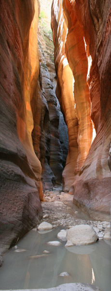
The bottom half of Orderville is wet - great fun when it is hot out. A backcountry water-park. Water protection for cameras and anything else you want to keep dry is essential. The footing can be uncertain, and the technical difficulties are few, so ski or trekking poles, or a hiking staff, are useful.

Canyon Profile
Logistics

RATINGS
3BIII ★★★☆☆

TIME REQUIRED
6-10 Hours

PERMIT
REQUIRED. Group size limit 12.

SEASON
Summer or fall

LONGEST RAPPEL
15 feet (3 m)

SKILLS REQUIRED
NO JUMPING!
Equipment

ESSENTIALS
Helmets, short rope and rappelling gear. Good wading/hiking shoes.

COLD WATER PROTECTION
Wetsuits or drysuits in all but the hottest weather. Drybags for your gear.

DRINKING WATER
The first half is dry; water available to filter in the second half.

FLASH FLOOD RISK
Moderate - There are no continous narrows where you would get swept away. The drainage is large but vegetated and low-angle. Flooding of The Narrows or Orderville could require an overnight stay.

ACCESS
Requires car spot or shuttle service to the Orderville Trailhead, located on dirt roads on the North Fork Road. High clearance vehicles suggested. Ends at Temple of Sinawava.
Summer- Start early to avoid the heat, the first half of the hike is usually dry and in full sun. Bring plenty of water.
Fall- Wetsuits recommended for cooler temps and shorter days. Beautiful fall foliage usually present in the upper half of the canyon.
Winter- Can be hard to access the top trailhead when the North Fork road is wet, snowy or icy.
Spring- Check for closures for spring snowmelt in the Narrows. Wetsuit recommended.

Getting there
Orderville starts at the Orderville Corral, just off the North Fork Road, 11.4 miles from Utah Route 9. The dirt part of the North Fork road can be impassable when wet, even for fully-capable 4WD vehicles.
From Springdale, take Utah Route 9 through the Park and 2.3 miles past the East Entrance. Turn left (N) on the North Fork Road - mileage starts here. The road is paved for 5.4 miles, then turns to dirt. Six miles on the dirt leads to a left turn for the signed for Orderville Canyon ORV Area - the Orderville Corral. Follow the road .1 miles across the field to a corral, and park among some trees. Those with a true HC 4WD vehicle can continue down the steep, rutted jeep trail another 2.2 miles.
A shuttle to the Orderville Corral can be arranged from Springdale. Contact Zion Adventure Company at 435-772-1001.
Approach
Follow the rutted dirt road steeply downward. At the bottom, follow the dirt road beside the creek downcanyon. In about an hour, the burly-vehicle carpark appears, a big flat area where some can park. A half-hour walk beyond this, the canyon drops dramatically in a rocky dryfall. Follow trails left, then down steep dirt to the canyon floor. These Carmel-formation silts are the source of the super-slippery clays that make Orderville so slippery after a good rain.
The Business
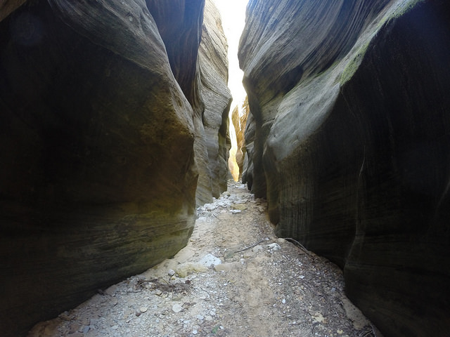
Stroll downcanyon. At first, the canyon is open with large trees, punctuated by short sections of interesting narrows. The narrow sections become longer and more frequent, the terrain providing a wide variety of scenery. Numerous canyons come in from the north and south, including Esplin Gulch, named for Lynn Esplin, who made the first descent in 1947 while looking for missing sheep. Unfortunately, he did not survive his descent. Other drainages dropping into Orderville are named for pioneers that farmed in Orderville Canyon and ran livestock on the high ground to the north and south.
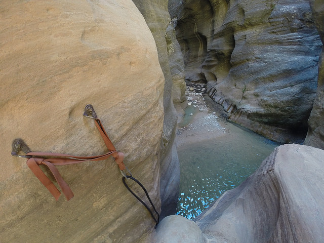
About an hour downcanyon from the mudslide, the hearty canyoneer arrives at the first obstacle. A large boulder blocks the canyon, with a bolt anchor on the right wall. This is the Park Boundary Boulder, as it is very close to the Boundary between Zion National Park and BLM land to the east. Youth groups and others not concerned with human frailty slide down the rock and jump to the ground below, but more mature individuals will wish to use a rope to rappel, or as a handline for downclimbing the chimney below the anchor. Slippery clays can make this treacherous – use caution.
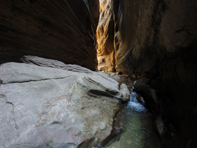
Further downcanyon, the narrows become more continuous. A few small springs provide water and a small flow starts. A log dam often backs up a shallow pool, and another one requires a short downclimb next to a waterfall. Stay in the watercourse in these areas and avoid using trails to the side that contribute to erosion.
The second obstacle is reached about an hour and a quarter past the first obstacle. A large boulder blocks the canyon. Thirty feet above the canyon floor, an even larger block spans the width of the canyon as a chockstone, and has been there long enough to have a lush growth of vegetation on its top. This is The Guillotine. Bolts and slings on the left side overlook a steep v-slot with logs leaning against it. This downclimb is especially slippery because the trees are polished and practically frictionless. Use the rope to rappel, or as a hand-line to assist and protect the downclimb. If there is water at the bottom, it is likely shallow.
A half-hour past this, another boulder blocks the width of the canyon. A scary-looking V-slot downclimb on the left looks like the obvious path, but following the water down a short fall on the right is easier and safer. This is Corkscrew Falls. Soon after, a slippery downclimb into an overhead-depth pool appears, for which a rope and handlines are likely a good idea.
Numerous interesting obstacles make for fun splashing in the water. In another half-hour, Veiled Falls is passed on the left using some shallow moki-steps. This is a popular destination for folks hiking upriver, so don't be surprised to find a crowd. A couple of downclimbs past logs might require a short swim. About an hour past The Guillotine, the final narrows section soars spectacularly skyward. Just beyond, Orderville joins the Narrows. Turn left and hike downstream about an hour to the Veranda at the end of the paved path leading 1 mile to the Temple of Sinawava.

The Exit
Turn left at the Junction with the North Fork Narrows and hike downstream about an hour to the stone veranda at the end of the paved path. Hike the paved Riverside Walk 1 mile to the Temple of Sinawava, where you can catch the free shuttle April-October.
Trip Reports

Maps
Click for higher resolution
Click for higher resolution.
Click for higher resolution.