

Got a vehicle?
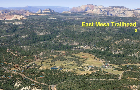
If you yearn to gaze down from Observation Point, but feel intimidated by the the 4-mile, 2150-foot climb to reach it from Weeping Rock trailhead, East Mesa trail may solve your problem - so long as you have wheels. An hour's drive from Springdale/Zion Canyon to the heights of the East Side converts an outstanding workout into a casual stroll to the same stunning overlook. Getting to the trailhead, however, requires a high clearance (or rental) vehicle, due to the rutted road. Once you do attain the trailhead, a wide, flat trail leads through a beautiful, sparse forest to Observation Point.
HIke Profile
Logistics

RATING
Moderately strenuous hike

TIME REQUIRED
3-4 hours

SEASON
Spring, summer, fall

LENGTH
3.4 miles (5.4 km) each way

ELEVATION GAIN
280 feet (85 m)

ACCESS
Start and finish at East Mesa Trailhead OR you can continue down the East Rim trail to Weeping Rock Trailhead (shuttle or car retrieval required).

SHADE
Most of the hike is in the full sun, though the 2500-foot altitude gain provides somewhat lower temps than the Main Canyon.

PERMIT
No.
Equipment

ESSENTIALS
Sturdy hiking shoes, ample water and food for a half-day hike.

DRINKING WATER
No water available at trailhead; fill up before you leave town.
DIFFICULTIES

CONSIDERATIONS
Access to the trailhead requires high clearance vehicle.
Seasonal Adjustments
SPRING - A great time to hike; look for flowers and new plants along the drainage.
SUMMER - Can be HOT! Bring plenty of water.
FALL - Generally a good time to hike this trail.
WINTER - Ice and snowpack can gather on the road, making travel to the trailhead difficult to impossible without snowshoes and/or crampons, unless its unusually warm, dry winter.
Getting There
The East Mesa Trail begins on the Park Boundary, accessed through the Zion Ponderosa Ranch Resort. Allow an hour driving time from Springdale.
From Springdale, take Route 9 up Pine Creek Canyon toward Mt. Carmel Junction. From the East Entrance, continue 2.4 miles east, then turn Left (North) on the paved North Fork Road. Follow the winding road 5.1 miles to the Zion Ponderosa Ranch Resort, where the pavement ends; turn left into the Ranch. The following mileage points are given from the entrance.
The dirt roads from here are rough and not well signed. Please be respectful of Ponderosa residents you encounter; they may be afoot, on ATVs, on horses, or in cars. You are a guest on the Ranch. A few, but not all, of the turns are marked for "Observation Point."
0.0 miles: At the entrance, go straight past a residence. Avoid going down to the main resort building to the left. Pavement ends.
0.4 miles: Y intersection - go Right.
0.7 miles: T - go Right for Observation Point (Twin Knolls Road).
1.5 miles: T - go Right.
2.3 miles: Fir Road crosses - go straight. Road gets worse. Park here if the road is wet.
2.6 miles: Deeply rutted hill - this is the worst spot. Some 2WDs will park at the top of the hill.
2.65 miles: Big Pine in center of road, rough. Go Left around pine, then Right down the hill.
2.9 miles: Y - go Left for East Mesa Trailhead
3.0 miles: End of Road at Park Boundary: Parking lot.
For those of you with GPS: UTM Nad83: 331502mE 4129428mN
The Hike
Stroll on the wide, smooth trail, 3.4 miles to Observation Point. The trail is on the mesa top with huge Ponderosa pines and signs of recent fires. Pass the top of Mystery Canyon at 2.1 miles (3.4 km). Intersect with the East Rim Trail at 3.0 miles (4.9 km). Go right. A further 0.4 miles (0.6 km) finds you at a spectacular overlook.
Return the way you came, or send the driver back and hike down the Observation Point Trail to Weeping Rock, and take the park shuttle back into town.
Observation Point (either way) can be combined with Hidden Canyon or Echo Canyon (from the Bottom) to make a more substantial day.
Maps
Click for higher resolution
Click for higher resolution