


SUBLIME.
The Subway is the most popular backcountry hike in Zion, and for good reason! In a park of exemplary beauty, The Subway is one of the most diverse and beautiful canyons—NOT to be missed. A few short rappels and a couple of short, mandatory swims add spice to the adventure.
The Subway is a short, spectacular section of the Left Fork of North Creek. The canyon system is called the Great West Canyon, including both the Left and Right Forks. The Subway section is not marked on maps, but is where the Left Fork tightens up and twists sharply, between North Guardian Angel and Guardian Angel Pass. The hike is also known as "The Left Fork".
The route starts at the Wildcat Canyon Trailhead and descends to the Left Fork via a cross-country route that crosses Russell Gulch, walks out a ridge and descends a steep gully. The Left Fork is followed through The Subway, then downcanyon a few miles. A short, steep trail is then climbed to the road, ending at the Left Fork Trailhead.
Due to its popularity, The Subway is managed under a quota system. Reservations are distributed by lottery several months in advance and are highly recommended. Surf over to the Wilderness Desk Website for the latest information and to enter the lottery. After lottery assignments are made, the remaining reservation spots can be booked over the Internet until the week before. After that, a new "Last Minute Drawing" allocates remaining spots via the Internet.
Last minute drawing applications are taken between 2 days (until noon) and 7 days in advance of the trip date for Slot Canyon Day Trips that have filled the reservable allocations. The last minute drawing runs 2 days prior to the requested trip date at 1pm MDT.
AFTER the last minute drawing, there may also be walk-up permits available one day in advance of, or the day of, your hike. Be flexible and plan ahead to avoid being denied.
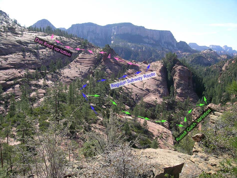
Those interested in adding some excitement to their Subway day should check out the Russell Gulch and Das Boot variations.

Canyon Profile
Logistics

RATINGS
3BIII ★★★★☆

TIME REQUIRED
6 to 12 hours

PERMIT
YES, and permits are hard to get.

SEASON
Summer or fall

LONGEST RAPPEL
30 feet (10 m)

SKILLS REQUIRED
The Subway is a strenuous and demanding backcountry
hike with rappels and swims. Good navigational skills are
required - straying into more difficult terrain on the
approach, or missing the exit, is hazardous. There are
three short drops, the last of which REQUIRES
rappelling. Folks must know how to rappel, and how to
use conspicuous anchors. You will need drybags for your
gear. Wetsuits are needed except in high summer.
Equipment

ESSENTIALS
Dry bags for your gear. Helmets, rappelling gear, webbing and rapid links.

COLD WATER PROTECTION
Wetsuits or drysuits in all but the hottest weather. Protection for your gear.

DRINKING WATER
The canyon's pools are springfed, so reasonable water is available to filter once in the canyon; but most people bring enough for the entire trip.

FLASH FLOOD RISK
Moderate – There are only a few sections of sustained narrows.

ACCESS
Requires car spot, shuttle service or short hitchhike.
SEASONAL ADJUSTMENTS
Summer - In hot weather, The Subway can be enjoyed without a wetsuit for all but the skinniest. An early start (trailhead at 7:30 am) will allow the sunny approach to be completed before it becomes sweltering. The hike out can also be very hot, and taking a siesta at the end of The Subway part is often a good idea.
Fall - In cooler weather, wetsuits add to the enjoyment of The Subway. Zion has short days in late fall, which often means starting or ending by headlamp. AWESOME with red leaves floating in the water.
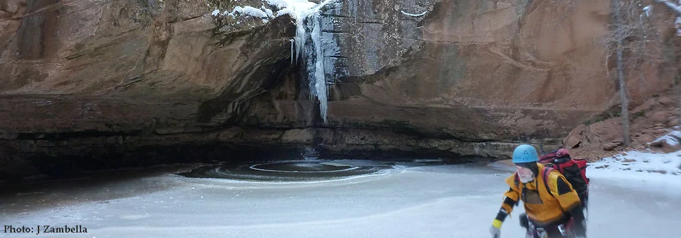
Winter - The Subway is a poor choice for winter. Those who have done the canyon before can maybe pull it off if there is no snow.
Spring - In Zion, spring occurs sometime in March, April, May or June. For several weeks in that time period, the basin feeding The Subway melts off and The Subway floods, with too much water for safe passage. There is no gauge on the stream so water level information is not available remotely. Winter conditions may apply, and access to the trailhead might be blocked with snow. The route can be difficult to follow if obscured by snow. Snow and ice in the canyon can make downstream travel difficult or impossible! The red ledges at the bottom of The Subway can be slabs of ice requiring crampons.
| Landmark | Hours | Hours Total | Miles/Km | Miles/Km Total |
|---|---|---|---|---|
| Wildcat Canyon Trailhead | 0:00 | 0.0 | ||
| Northgate Peaks Trail | 0:30 | 0:30 | 1.3/2.1 | 1.3/2.1 |
| Turnoff to Subway Route | 0:05 | 0:35 | 0.2/0.3 | 1.5/2.4 |
| Cross Russell Gulch | 0:25 | 1:00 | 1.0/1.6 | 2.5/4.0 |
| Bottom of Russell Gulch | 0:30 | 1:30 | 1.0/1.6 | 3.5/5.6 |
| First Obstacle | 0:10 | 1:40 | 0.3/0.5 | 3.8/6.1 |
| Triple Pool | 0:20 | 2:00 | 0.3/0.5 | 4.1/6.6 |
| Slot Swim | 0:30 | 2:30 | 0.4/0.6 | 4.5/7.2 |
| Keyhole Falls | 0:30 | 3:00 | 0.4/0.6 | 4.9/7.8 |
| End of Subway/Red Ledges | 0:30 | 3:30 | 0.3/0.5 | 5.2/8.3 |
| Dinosaur Tracks | 1:00 | 4:30 | 1.5/2.4 | 6.7/10.7 |
| Start of Lava Slope Exit | 0:50 | 5:20 | 1.2/1.9 | 7.9/12.6 |
| Climb Steep Slope | 0:20 | 5:40 | 0.1/0.2 | 8.0/12.9 |
| Stroll to Carpark | 0:20 | 6:00 | 0.6/1.0 | 8.6/13.8 |
THE APPROACH
The Subway starts at the Wildcat Canyon Trailhead on the Kolob Terrace Road, and ends at the Left Fork Trailhead. In the summer, it is easy to hitch a ride from the Left Fork Trailhead the further 7 miles to the Wildcat Canyon trailhead. If you have one car, leave the car at the bottom (Left Fork Trailhead) with water, food and clothing. Hitching a ride is easier at the beginning of the day, when you are clean and smell nice. Or, arrange a shuttle from the lower trailhead to the upper with a local company such as Zion Adventure Company. In summer, get an early start to avoid the hot sun.
Spotting Cars
From Springdale, drive on Hwy 9 south and west 14 miles to the town of Virgin. Turn right (north) on the Kolob Reservoir Road (KR road, sometimes called the Kolob Terrace (KT) road). The paved KR road drives north a bit, then climbs a dramatic ridge in making its way to the Kolob Terraces. Six and a half miles from Virgin, the road enters the park and three trailheads are soon encountered – the Right Fork, Grapevine Springs, then the Left Fork. Park at the Left Fork Trailhead. The trailhead is not shown on many maps, but is close to the Bench Mark labeled BM 5248. Mileage from the town of Virgin is 8.6 miles. Driving time from Springdale is 45 minutes.
The Approach
The Park re-aligned the "trail" in spring 2012, and made it quite a bit better, with more time on the slickrock and less in the woods. However, it is still a backcountry "route" rather than a "trail", so it requires attention and some backcountry savvy to follow. Straying from the trail tends to lead to "cliffs" - so make the effort to stay on the route. If you lose the route, please backtrack to the last place you had it. If the terrain in front of you does not match the description, you have probably lost the route. If the drop you come to looks longer than 30 feet, you might be at the bolted first rappel in Russell Gulch which is 100 feet, and on which your 60 foot rope will not magically get you safely to the bottom. Turn around and go back to the trail. The standard route to The Subway is called the Russell Gulch Route, but it does not follow Russell Gulch, it crosses it. There is also a "Russell Gulch Start" that descends
the gulch with three 100-foot rappels.
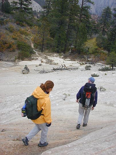
For the regular route, head east from the parking lot on the old fire road as it crosses the open meadows of Kolob Terrace. Open areas intersperse with stands of Ponderosa Pine. After 20 minutes, the signed Hop Valley Connector Trail comes in from the right. This trail is not shown on some maps. Continue straight. Five minutes later, the signed Northgate Peaks Trail comes in on the right - take this trail to the south. A few minutes down the Northgate Peaks Trail, take a well-marked trail that branches left (east) to the top of a slickrock area. There is a sign: "Subway Hikers". The maintained trail ends here.
Work your way down and right, staying to the slickrock and following cairns. Thirty feet above the woods, follow a sidewalk-like ledge to the right that traverses at that level for 100 yards. Look for and take a small sandy trail and drainage on the left that cuts across the woods to the next slickrock area. Follow the drainage on the rock until it threatens to plunge over a short drop into the forest. Do not plunge, instead hike to the right and down through brush until it comes back onto the rock. Follow ledges right to a large ponderosa log; hop the log and cut left and follow the slickrock down to a small trail that enters the woods. Follow the trail through the woods then out to a lava-boulder-strewn area where the trail is still clear. The trail continues out and left, eventually gaining and following the top of a ridge. A sandy trail leads to the end of the ridge with good views of the terrain ahead.
After enjoying the view, cut back left forty feet and downclimb a step, then a steep slab. Follow the ridge and trail beyond as it descends to, then crosses the small stream of Russell Gulch, then climbs to the slickrock pass ahead. Descend the bowl on the other side, then continue straight, then a bit right and find a trail that crosses the brush and comes out onto yet another slickrock area. Cut left and climb to the crest of the ridge beyond, over the crest and then right to follow the ridge briefly, until ramps lead left and down to the wash below, with conspicuous trails on the far side. Follow a well-established trail through the brush to the end of the ridge, overlooking a steep drop on two sides.
Normal approach time to the end of the ridge is 1-1/2 to 2 hours.
Follow the trail as it goes over the edge, then as it swings to the right, and steps further right to attain the top of a steep, rocky and sandy gully. Carefully descend the gully to the floor of Russell Gulch. In wet times, there is a pool, often waist-deep, at the base of the gully. If you have wetsuits you may want to put them on here. Follow Russell Gulch to the left 30 yards where it meets the main canyon, which is the Left Fork of North Creek.
The Business
Entering the Canyon
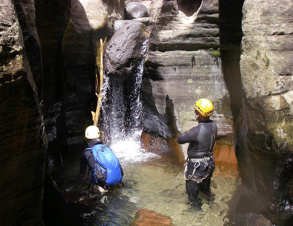
Turn right and boulder-hop down the (usually) dry canyon to the first obstacle - a jumble of giant boulders. If the canyon is running with water, evaluate if the flow is too high for your group's abilities. 100% of the water is funneled through a two-foot wide slot in two places - you will need to be in that slot with the water and not be swept away.
First Obstacle
The first obstacle is a pile of giant boulders that blocks the canyon wall to wall, and provides no conspicuous way down without using a rope or downclimbing something not all that easy. There are several options. Follow signs of traffic to the right wall of the canyon and a giant boulder with a two-bolt anchor near its top, and a V-Slot between the boulder and the canyon wall.
Option A: The Rabbit Hole: This is the easiest and funnest way down. Look across the canyon to the left wall, across from the bolted boulder. There is a small flat ledge with two holes behind it, and sometimes a cairn. Cross the boulders and crawl into the most up-canyon of the holes, then down and through another hole to come out on the canyon floor. Easy!
Option B: Rappel 30 feet (9m) the downstream face of the boulder. A short rappel can be made down the face of the boulder. It is often easy for most of the way, then for the final five feet, then boulder cuts away underneath.
Option C: From a single-bolt anchor on the next boulder up-stream, rappel or handline the V-slot. I have always found this very awkward, and the rope can get stuck on the pull, especially if there are logs in the V-slot.
Continue Downcanyon
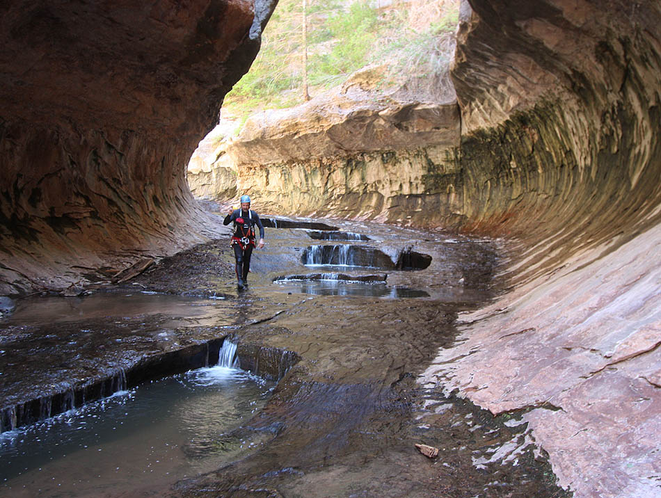
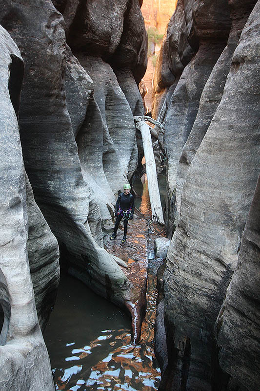
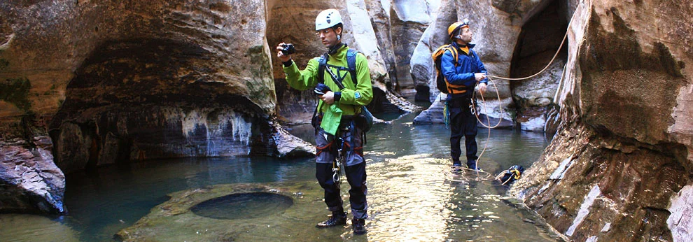
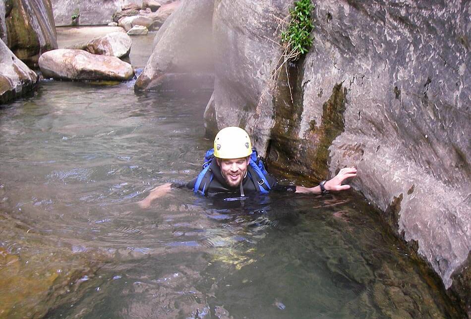
A few nice potholes are avoided by climbing rock on the sides; a few more are waded to perhaps waist deep. About 15 minutes below the first obstacle, the Triple Pools present the first mandatory swim. Ascertain your gear is properly dry-bagged, and swim the three pools. Bonus style points are awarded for swimming through the underwater arch on the left, at the start of the third pool.
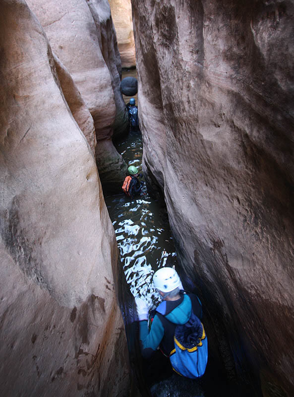
To The Subway
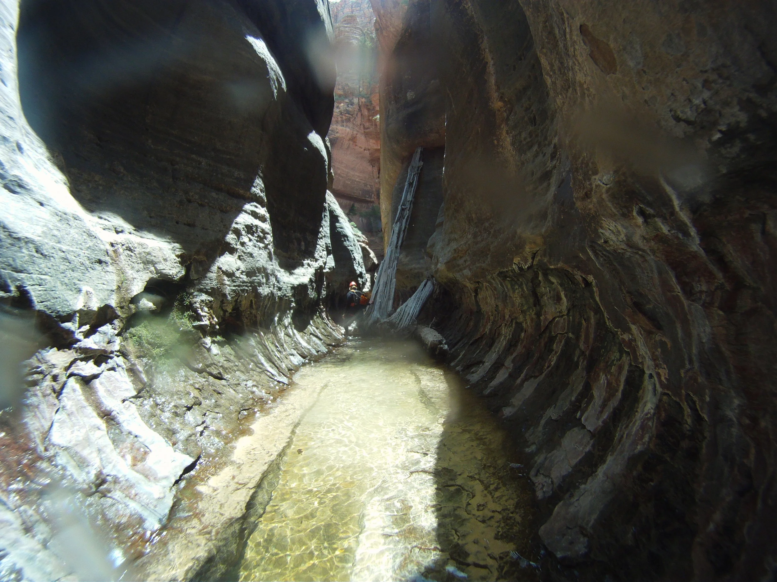
A few minutes downcanyon, springs start providing a small, year-round flow. Often the spring water is warmer than the retained water in the Triple Pools. Fifteen minutes downcanyon, the canyon narrows to a slot, with a couple short drops. Downclimb a couple short drops and climb over a chockstone then out through a large pool. (Variation: the slot can be avoided by a traverse up 20 feet on the left. Follow this out to the end, where a short rappel can be made from a tree. Getting up to the traverse is not easy.
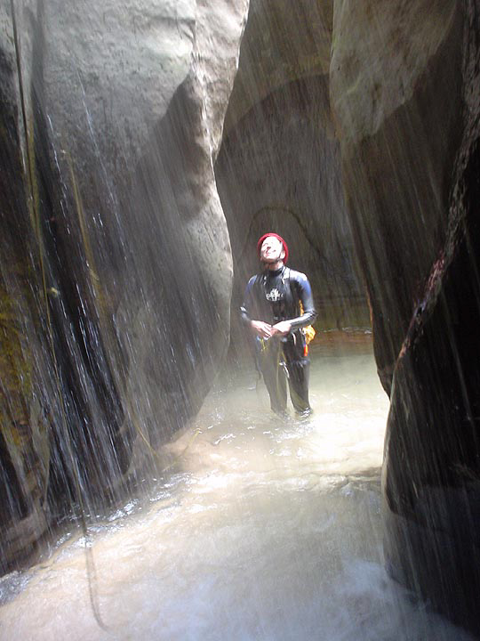
The canyon in this section is exceptionally beautiful. Five or ten minutes downcanyon, the final section begins at Keyhole Falls. The stream drops through a slot with a small arch on the left. Rappel 10 feet from bolts on the right into water that is usually waist-deep. Downclimbing this drop is difficult because the landing is very bad. Bowling-ball size rocks are hidden beneath the churning water.
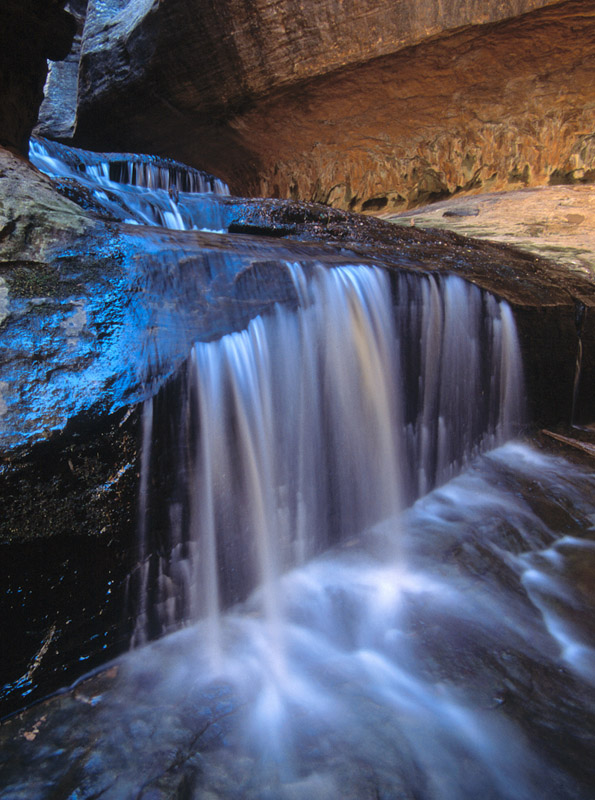
You are now in an amazing corridor. Swim through an arch on the left for a few more bonus points. At the end of the corridor, the canyon turns sharply right, revealing the famous "North Pole" log. Take pictures, downclimb a short shelf and wind your way downcanyon. Where the canyon opens somewhat, with the waterflow on the left wall, rappel the final drop from a 2-bolt anchor on the right. This rappel is quite steep, and is not suitable for handlining. Once down the drop, the waterfall and the room behind it are often fun to visit.
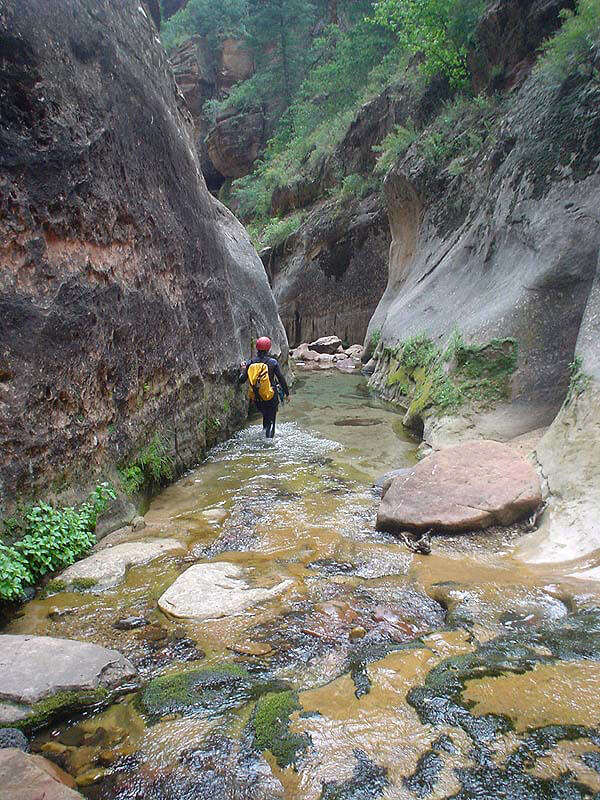
Continue downcanyon past some lovely pools. The rock can be very slippery here, so be careful. Soon you are walking through the eponymous "Subway" section, where the curving canyon walls and parallel cracks in the floor call to mind underground trains. Past this, the canyon opens up and flattens out, and there is often comforting sunshine. Many groups remove their wetsuits and harnesses here, and warm up in the sun. If it is hot out, take a siesta until the sun is lower in the sky.

The Exit
The Walk Out
The exit continues down the Left Fork and is long and rugged. The first part descends marvelous and photogenic red ledges with waterfalls. A few minutes below the red ledges, a spring drops water into the stream on the right. Following paths on both banks and crossing the stream many times, make your way downcanyon. Most parties take two and a half hours for the hike out. About one hour downcanyon, look for two large tumble-down boulders close to the water on the right. Their flat, gray faces hold many dinosaur tracks. Admire but do not touch these fragile remnants of the past.
The Climb Out
Another hour downcanyon and it's time to exit up to the road. Missing the exit is easy, so make sure you pay attention. Two streams come into the Left Fork from the north (right). One third of a mile (1/2 km) past the second stream, the exit gully will be in front of you. The north (right) wall of the canyon is a 400-foot (120m), steep, tree-covered talus slope with 400-foot (120m) vertical sandstone walls above. Downstream, the sandstone at the top ends and a black lava flow replaces the steep talus. The trail out climbs the crease below the left edge of the vertical sandstone to where it meets the lava flow.
The climb can be extremely hot - the black rock traps afternoon heat. Take a final dip in the stream before starting up. Find the well-established trail on the right side of the creek that starts up a gully. Do not begin the climb up without finding the trail. At the top of the slope, the trail traverses left to the top of the lava flow and works its way left through ledges to the mesa top above. Follow the trail through the pinon-juniper forest 1/2 mile (800m) to the parking area. Enjoy the ice-cold beverages you left in your cooler.
In the (geologically) recent past, lava flowed over the edge and into the Left Fork, forming a dam. The creek gradually built a lake until it over-topped the dam and cut its way through. Soft sandstone from the lake deposits can be seen lying on top of the lava in a few places just after reaching the top of the steep climb out. Look for these thin-layered, soft sand- and siltstones.
Trip Reports
Maps
Click for higher resolution.
Click for higher resolution
Click for higher resolution.


Zion's Subway is a wonderful, beautiful canyon, enjoyed by many people in several different ways. I made a run through on a recent weekend to re-locate the first anchor, bolted this spring but not in the best place (from my point of view).