A Remarkable Journey.
The Right Fork traverses across the Zion backcountry-scape to access a delightful canyon with a few raps and swims. For many people, finding the correct route is the crux. The first descent was by Victor A. Schmidt and company, June 29 – July 2, 1966. They pioneered the intricate route still used today to avoid a long string of linked potholes in the Upper Right Fork (Right Fork Direct). After carefully studying aerial photographs, the group found a series of potholes they thought would be beyond their limited technical experience. Follow the route carefully. If you do not read and understand topographic maps, pick a different adventure.
The middle section of the canyon, between the turn southwest and Double Falls, is where the "goodies" are. The Grand Alcove and several lovely waterfalls are often the highlight of the trip, though many will also enjoy The Black Pool. Many parties bivy at the Grand Alcove where the first springs appear, offering high-quality water.
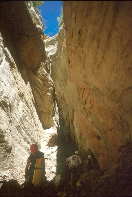
Two variations are available that add more technicality to the trip. The Hammerhead has six rappels that connect the West Rim trail with the Right Fork and is the true start of the Right Fork drainage. The Upper Right Fork Direct goes through the series of potholes avoided so carefully in 1966; they turn out to be fun, wet, technical, and, in some conditions, quite difficult. It is possible to bivy at the start of the Right Fork Direct in all but the driest conditions by pumping water from any of several large persistent potholes.
Trip Variations
There are several different ways of doing the Right Fork. Speed demons will get an early start and can run it in one day. A two-day trip requires an early start; a quite-long first day gets you to the Grand Alcove, then the second day is still a full day. A three-day trip starting at the West Rim, taking the Direct Right Fork, bivying on ledges near the start of the Direct section then bivying again at the Grand Alcove, makes for a delightful, relaxed trip. For small, competent parties, the Hammerhead entrance adds an hour or two. For large or inexperienced parties, working largish packs through numerous downclimbs and rappels can add three or four hours to the descent. The Direct section adds two or three hours to a Right Fork Trip, even for experienced canyoneers.
In all cases, the terrain traversed is rugged, and smaller packs will result in a faster trip. Pack light.
RATINGS
• Standard Route: ★★★☆☆
• Hammerhead: ★★★★☆
• Direct Right Fork ★★★★☆
• Hammerhead plus Direct Right Fork: ★★★★☆

Canyon Profile
Logistics

RATINGS
3B IV or V ★★★★☆

TIME REQUIRED
2 to 3 days

LONGEST RAPPEL
Standard route - 60 feet (20 m)
Hammerhead - 165 feet (50 m)
Direct - 80 feet (25 m)

PERMIT
YES. Group size limit 6.

EMERGENCY
Zion Wilderness Desk: 435-772-0170
Zion EMERGENCY: 435-772-3322

SEASON
Summer or early fall. The lower part of the canyon is in the full sun.

ACCESS
Requires car spot or shuttle service.
SEASON
The Right Fork begins up high and traverses a wide variety of terrain. With any snow, conditions are unpredictable. The canyon might take its sweet time drying out in the spring. The Hammerhead will typically hold snow well into June.
Equipment

ESSENTIALS
Map, helmets, rappelling gear, webbing, rapid links.

COLD WATER PROTECTION
Wetsuits or drysuits generally required. Drybags for your gear.

DRINKING WATER
Limited. Carry some and bring a pump. Pumpable water is found at the seep seasonally. Springs start at the Grand Alcove.
difficulties

FLASH FLOOD RISK
Moderate - There are only a few sections of continuous narrows.

ANCHORS
A mix of natural and bolted anchors.

SKILLS REQUIRED
Difficult navigation. For the Direct, there can be keeper potholes.

Getting there
Getting There: From Springdale, drive south and west 14 miles to the town of Virgin. Turn right on the Kolob Reservoir (KR) road. The paved KR follows North Creek then climbs a dramatic ridge in making its way to Kolob Terrace. Six and a half miles from Virgin, the road enters the park and three trailheads are soon encountered - Right Fork being the first. Park at the Right Fork Trailhead, 7.0 miles from the town of Virgin. Driving time from Springdale is 45 minutes. This is your exit point; leave a car here.
The top of the route can be accessed from either the West Rim Trailhead or from the Wildcat Canyon Trailhead. The first is a shorter hike but a longer drive and will be described here. Wildcat Canyon Trailhead will work better if you have only one car or if the Lava Point road is closed. If you have one car, leave it at the Right Fork Trailhead. Or, arrange a shuttle to transfer from the Right Fork Trailhead to Wildcat Canyon Trailhead or the West Rim Trailhead with Zion Adventure Company.
Approach Hike from West Rim Trailhead: Hike down the West Rim Trail 500 feet (150m), then branch right onto the Wildcat Canyon Trail. Follow this 15 minutes (0.7 miles), then drop south off the trail through brush to the bottom of Little Blue Canyon (not labeled on the map). Follow the bottom of Little Blue southwest until it drops steeply into Wildcat Canyon. Make two 75-foot (20 m) rappels into into a lush glen. Hike a short distance to the main Wildcat Canyon.
Alternatively, stay on the trail another half mile and drop into Wildcat Canyon where the trail crosses the visible drainage, avoiding the two rappels of Little Blue Canyon.
Approach Hike from Wildcat Canyon Trailhead: Follow the Wildcat Canyon Trail 4.1 miles to where it crosses- you guessed it- Wildcat Canyon, and plunge down the watercourse from there.
Alternate Technical Approach: The Hammerhead. The hammerhead-shaped canyon 0.2 miles SE of PT 7325 on the West Rim makes a reasonable and way more technical entrance to the Right Fork. Hike the West Rim Trail to Potato Hollow, then follow the trail south. Where the trail cuts a hard left, follow grasslands up a wide valley then right. There should be minimal bushwhacking up to a shallow pass overlooking the south end of The Hammerhead. Traverse the rim until you are above the north end and work your way down the slope to the first rappel. The brush is terrible and the terrain hard to read, so a GPS is recommended. Six rappels to 165 feet (50 m) from natural anchors and several downclimbs are required to reach the Right Fork. At the intersection with the main canyon, descend the steep nose on canyon left to reach the floor of the canyon, then follow the canyon left (brushy, narrow). From the bottom of the Hammerhead to where the regular route comes in is only 2/3 of a mile but has considerable canyon action. Narrows sections can be traversed around or dealt with directly; some might have keeper potholes or other challenges.
The Business
Wildcat Canyon: an open, rugged and dry canyon with large cliffs on both sides. Follow the bottom of the canyon easily for a mile and a half until it becomes more rugged and brushy. Avoid difficulties by staying right of the canyon bottom on the benchland where the walking is easier. Follow the bench for 3.2 miles, crossing a wash. Just short of where Wildcat Canyon turns right and joins the Left Fork, follow social trails eventually to a ramp that leads easily down into the canyon. Follow the canyon bottom for 1/10 mile (160 m) to an easy exit up slabs on the left (east) where The Seeps come in. This is likely the first drinkable water found on the hike, though the flow is often a tiny trickle. The potholes in the canyon might offer a better source for pumping.
Up to the Pass: Hike south-southeast, climbing up a wide, open and dry valley. There are some incredible Ponderosa Pines protected by the very large sandstone walls on each side. Cresting the pass, the terrain to the south is very rugged. A bivy site near the pass offers excellent views.
Descend the Valley and Climb to the Shelf: Stay to the right to avoid the rugged canyon on the left. Follow game trails down and into a small drainage that joins with the main canyon on the left in thirty minutes. Follow the main drainage for only a few minutes, to slickrock that starts to slot up and form potholes. This is the start of the more-technical Direct Right Fork (*see description at bottom) section that most parties will wish to avoid. (A bivy is possible here, with water pumped from large potholes).
Backtrack a few minutes and find a social trail or game track ascending the steep, wooded slope to the west. Climb several hundred feet to the crest. Once atop the ridge, a faint trail-of-use makes travel easier. Follow the crest of the rib to near its end, then drop into a beautiful, shallow slickrock canyon on the right, and follow the "Giant Staircase" to its end. (This is the last place to bivy before dropping into the narrow canyon). Where the canyon drops precipitously, downclimb steeply to the left, using the trees and carefully searching out the easiest route. Rappels should not be necessary. Near the bottom, step across the watercourse and follow a shelf 40 feet above the watercourse until it is easy to drop into the canyon. You may need to use a handline to get to the canyon floor. Some people bivy in this vicinity. Water may be available in potholes.
The Right Fork: Finally, in the cool confines of the Right Fork! The canyon is deep and shaded with a rocky bottom – but also rugged so downstream travel is slow. The wise canyoneer will hunt for options at each obstacle, choosing the fastest and safest route down. This stretch to the Grand Alcove is only 1.3 miles (2 km) long, but takes 2-3 hours to traverse. Hike downcanyon under a giant boulder. A few minutes later, the canyon turns sharply right. In about 20 minutes, the Infamous Black Pool is encountered.
Rap into the pool, and swim 0 to 50 feet to 100 yards through a sinuous sandstone slot. Brrrrrrr. Rumor has it the pool can be avoided by a traverse on the left then by rapping off a tree into the end of the pool. But, what's the point?
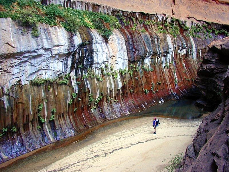
Walk briskly to warm back up. Other obstacles are overcome, rappels made, pools swum. Close to the Grand Alcove, a little flow starts up in the canyon bottom. After several hours of rugged canyon travel, you arrive at The Grand Alcove, a magnificent overhang with multiple colorful tiers. The canyon cuts through the aquifer layer and copious quantities of clear, clean water burst out of the walls. This makes a splendid camping place - requiring your best minimum impact camping technique.
The Grand Alcove was named the "Stevenson Alcove" by the first descent party of Ron Shofner and Bill Fisher et al. in July 1965. Adlai Stevenson died a few days before they started their trip. Later authors did not propagate this name.
The Grand Alcove comes with a cliff obstacle that can be rappelled on the left at the far end of the ledges off a fixed anchor. A second, short rappel is made off a tree to the canyon floor. But, way WAY more fun -- the streambed flume can be slid and downclimbed directly to the pool at the bottom, which makes for a refreshing morning swim and is a wonderful section of canyon.
Barrier Falls: One hundred yards below the Grand Alcove, a 60-foot (20 m) waterfall is rappelled from bolt anchors. Barrier Falls represents the furthest the canyon can be hiked from the bottom. There is a lot of poison ivy from Barrier Falls out to the trailhead. Heading downcanyon soon leads to...
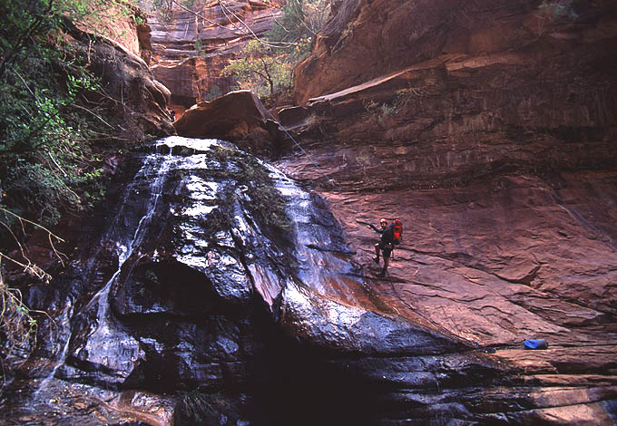
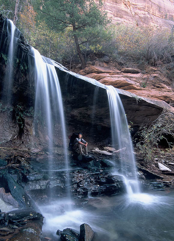
More Waterfalls: A splendid waterfall appears difficult, but is easily passed by a trail to the side. The next fall might require a rappel. After that is Double Falls - passed on the left or rapped on the right. A ledge passes behind the twin waterfalls, allowing the adventurous canyoneer to dive through the waterfall into the pool beyond. Big boulders and rugged terrain make this section slow going.
* Upper Right Fork Direct: The series of linked potholes in the Upper Right Fork can be descended directly. Climbing skills may be required to exit one or two of the potholes, and rappels up to 80 feet will be found, all from natural anchors. At times, there are REAL keeper potholes requiring tricky work to get past. The potholes call for greater protection from cold water than the regular Right Fork route. This variation adds 1-2 hours to the normal descent.

The Exit
The Slog: Unfortunately, Double Falls represents the end of the 'goodies' and the beginning of the slog out. The streambed is kinda like the end of The Subway but twice as long and a lot more interesting. Follow the streambed and side trails west for 4 miles to the junction with the Left Fork. Where the stream cuts an "inner gorge", follow the stream in the gorge.
Poison ivy is prevalent in this part of the canyon, so keep a keen eye and stay away from suspect vegetation as much as possible.
From the junction with the Left Fork, cross the stream and head south (left) on the opposite bank. A quarter mile below the junction, a path heads up and right to the lava cliff band. Keep your eyes peeled – while the path is marked, it is still an unofficial trail and can be easily missed. Follow the trail up through the steep talus then up through the cliff band of black lava to the Right Fork Trailhead. Near the start of the trail up, a good swimming hole is available for cooling off on hot days.
The last three miles to the road were impacted by a large fire in June 2006, and the trail may be difficult to find and follow through this section. At times, a landslide forms a lake that requires an extended swim.
Author's Experience
I first descended the Right Fork from the top in summer 1999 with Bill Reimann. I have descended it a couple of times since then, including the Hammerhead approach and sometimes including the Direct Right Fork, when possible.
Right Fork Fest, 10/19/02 : The first descent of The Hammerhead.
Stevenson Canyon, July 2007 : The first descent of Stevenson Canyon.
Hammerhead with Obstacles, Oct 2017: More recently, I descended the Hammerhead/Direct Right Fork in two long days and was surprised to find difficult conditions in the Direct section, including a tough keeper pothole:
Trip Reports


Stories
Right Fork North Creek, July 17, 1965 : possible first ascent (or pretty close)
Right Fork First Descent, June 26-July 2, 1966 - This is the report of the first descent by Victor Schmidt, Fred Kissell, Hugh Young, Frank Acker, David Thompson and Carol Thompson.
Ultra Right Fork, July 2007 - Tom Wetherall, Canyon Tales Collection
Stevenson Canyon, July 2007 - Tom Jones, Canyon Tales Collection
Maps
Click for higher resolution
Click for higher resolution