

NATURE'S SCULPTURE.
The Subway is one of the best routes in the Park, and hiking up from the bottom gets to the best stuff without ropes and swimming. If you're carrying lots of camera gear, hiking in winter, or you are averse to ropes and swims, it is a great way to see The Subway.
The short version: hike down a 400-foot (120m) steep, loose gully. Pick your way up a rugged streambed for two hours. Enjoy some really nice scenery. Hike back down the streambed for two hours, then up the 400-foot steep, loose gully. If it is at all hot out, hiking in the streambed is hot, hot, hot. Bad hot, not good hot. Save energy for the strenuous hike uphill to get back to the car, and get an early start.
"The Subway" is a short, spectacular section of the Left Fork of North Creek. The canyon is called Great West Canyon. The Subway section is not marked on most maps, but is where the Left Fork tightens up and twists sharply, between North Guardian Angel and Guardian Angel Pass. The hike is also known as "The Left Fork".
Due to its popularity, the Subway is managed under a quota system. Reservations are distributed by lottery several months in advance and are highly recommended. The same permit is used for the Top Down or Bottom Up Subway, so you do not have to decide which way to do in advance. Lottery and Reservations are made on-line at the Wilderness Reservation System.
Be flexible and plan ahead to avoid being denied. A permit is required for hiking The Subway from the bottom or from the top – and it is the same permit. Group size limit is 12.
HIKE Profile
Logistics

RATINGS
Non-technical, moderately strenuous hike

DISTANCE/TIME REQUIRED
3.5 rugged miles (5.3 km) each way.
6 to 10 hours

SEASON
Summer, Fall

ELEVATION GAIN
1000 feet (300 m)

SHADE
Most of the hike is in the full sun.

PERMIT
YES - The same permit applies to The Subway from the Top or Bottom. Permits are required to enter the drainage.
Equipment

ESSENTIALS
Sturdy hiking shoes, ample water and food for a full day hike

DRINKING WATER
Water is available to purify, but bring ample water.

FLASH FLOOD RISK
Moderate - there are only a few sections of sustained narrows.

ACCESS
Starts and finishes at Left Fork Trailhead, on the Kolob Terrace Road
Difficulties

CONSIDERATIONS
A backcountry adventure through remote terrain. It requires navigation skills and a long hike out.
Seasonal Adjustments
Spring - Expect high, cold water due to spring runoff. If the stream is in flood, access to "the goodies" will be difficult.
Summer - HOT! Start early to avoid the heat and be aware the hike out is in full sun.
Fall - Generally a great time for this hike - great fall photography along the creek.
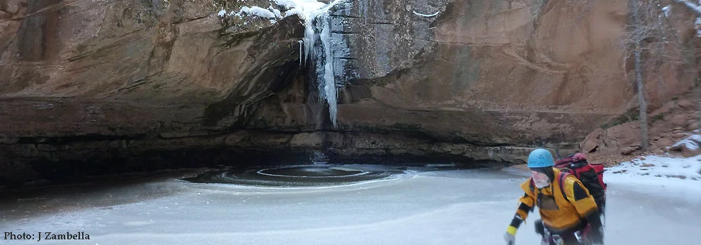
Winter - Possible snow and ice along the stream and at the red ledges.
| Landmark | Hours | Hours Total | Miles/Km | Miles/Km Total |
|---|---|---|---|---|
| Left Fork Trailhead | 0:00 | 0.0 | ||
| Top of Steep Slope | 0:15 | 0:15 | 0.6/1.0 | 0.6/1.0 |
| Bottom of Canyon | 0:15 | 0:30 | 0.1/0.2 | 0.7/1.2 |
| Start of Red Falls | 2:00 | 2:30 | 2.0/3.2 | 2.7/4.4 |
| Start of Subway | 0:15 | 2:45 | 0.4/0.6 | 3.1/5.0 |
| Play at Subway | 1:00 | 3:45 | 0.4/0.6 | 3.5/5.7 |
| Return to Start of Steep Slope | 1:45 | 5:30 | 2.4/3.9 | 6.0/9.6 |
| Climb Steep Slope | 0:20 | 5:50 | 0.1/0.2 | 6.1/9.8 |
| Stroll to Carpark | 0:20 | 6:10 | 0.6/1.0 | 6.7/10.7 |

Getting there
From Springdale, drive south and west 14 miles to the town of Virgin. Turn right on the Kolob Reservoir Road (KR road, sometimes called the Kolob Terrace (KT) road). The paved KR road winds through town, then climbs a dramatic ridge in making its way to Kolob Terrace. Six and a half miles from Virgin, the road enters the park and three trailheads are soon encountered – the Right Fork, Grapevine Springs, then the Left Fork. Park at the Left Fork Trailhead. The trailhead is not shown on many maps, but is close to the Bench Mark labeled BM 5248. Mileage from the town of Virgin is 8.6 miles. Driving time from Springdale is 45 minutes.
The trail

Follow the trail into the woods. In 15 minutes, the trail comes out on the rim of the canyon, with a great view of the Left Fork and the Guardian Angels standing proud to the east. Follow the trail left along the rim to where it drops into the canyon. Take great care to stay on the path as it descends steeply to the canyon floor. The trail is steep and loose. At least one person has died here when they strayed from the trail and fell.
at the canyon floor
At the bottom, turn around and make a careful mental note of where the trail up starts. You do NOT want to miss this on the way out. Cross the stream and turn left. This is a backcountry, off-trail route, so there is no official path, though there are well-established social trails and numerous stream crossings. After about two hours, the canyon gradually narrows as it approaches The Subway, where the stream gets more rugged and travel becomes slower and more difficult. Picking a way around the boulders and splashing up the stream, the intrepid Subway hiker finally comes to a series of Red Waterfalls, where the stream flows down slabs of dark red Kayenta sandstone. Hike up the slabs, then turn the corner and you are at the mouth of The Subway.
The Subway

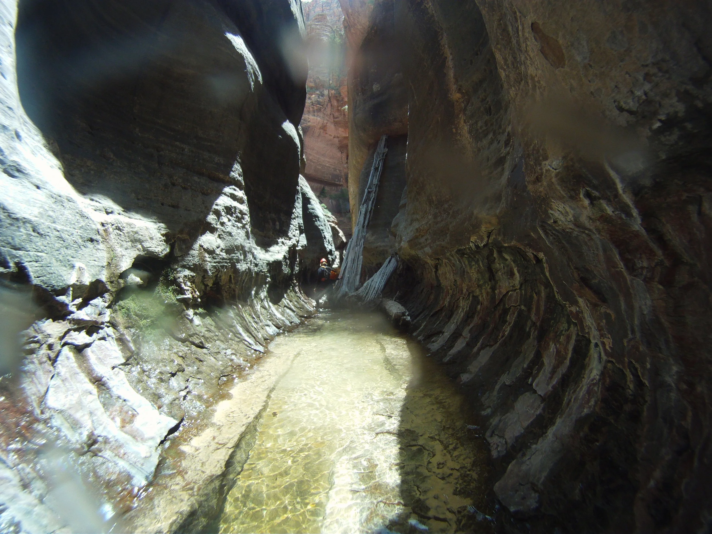
“The Good Stuff” is a series of slots, alcoves, pools and waterfalls of marvelous beauty, about a third of which can be easily reached from the bottom with a little swimming and climbing. It starts with the namesake tunnel-like formation: the top is not closed over to form a true tunnel, but it almost feels like it is. The bulgy, round tunnel at the bottom of a slot curves into the rock, with the solid red floor spotted with pools, slots and flowing water. Watch your footing here, the rock can be very slippery. The pools are filled with clear, clean water and are only a few feet deep. In the fall, red and orange maple leaves accent the red rock and make the place almost psychedelic.
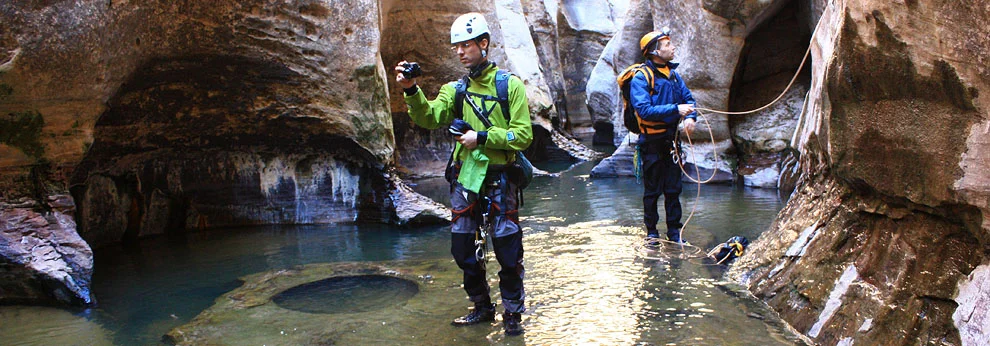
Around the corner, the canyon opens up a bit and larger pools block progress upcanyon. It is difficult to get up past the 20 foot cliff here, unless someone provides a rope from above. Getting back down requires a rope.

The Exit
The Walk Out
The exit down the Left Fork is long and rugged. The first part descends marvelous, photogenic red ledges with waterfalls. A few minutes below the red ledges, a spring drops water into the stream on the right. Make your way downcanyon, following paths on both banks and crossing the stream many times. Most parties take at least two hours for the hike out. About one hour downcanyon, look for two large tumble-down boulders close to the water on the right. Their flat, gray faces hold many dinosaur tracks. Admire, but do not touch these fragile remnants of the past.
The Climb Out
Another hour downcanyon and it’s time to exit up to the road. Missing the exit is easy, so make sure you pay attention. Two streams come into the Left Fork from the north (right). One third of a mile (1/2 km) past the second stream, the exit gully will be in front of you. The north (right) wall of the canyon is a 400-foot (120m), steep, tree-covered talus slope with 400-foot (120m) vertical sandstone walls above. Downstream, the sandstone at the top ends and a black lava flow replaces the steep talus.
Trip Reports
Maps
Click for higher resolution
Click for higher resolution.
Zion's Subway is a wonderful, beautiful canyon, enjoyed by many people in several different ways. I made a run through on a recent weekend to re-locate the first anchor, bolted this spring but not in the best place (from my point of view).