
A Shady Escape.
If you want to have Zion to yourself, get off the published trails to explore. The South Fork of Taylor Creek is a delightful canyon that makes a wonderful hot weather or rest day diversion. The Kolob Canyons section is about an hour's drive northwest of Zion Canyon and Springdale, but the hike is certainly worth the drive time.
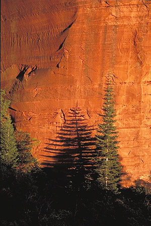
The South Fork is between Paria Point and Beatty Point, two jutting ridges of sandstone. Soaring sandstone walls enclose beautiful meadows, and easy walking leads into a lush, shaded forest. If you study the rock closely, you may be able to see bolts and/or anchor stations on the canyon walls, signs rock climbers have established climbing routes up the sheer faces.
hike Profile
Logistics

RATINGS
Mild to moderate hike

DISTANCE/TIME REQUIRED
1.2 miles (1.9 km) each way
1-3 hours

SEASON
Spring, summer, or fall

ELEVATION GAIN
400 feet (120 m)

SHADE
Most of the hike is in the full sun.
Equipment

ESSENTIALS
Bring sturdy hiking shoes, ample water, and food for a full day hike. Since Kolob Canyons has a higher elevation than the Main Canyon (and thus is about 10-15 degrees cooler), a jacket is recommended in Spring and Fall.

DRINKING WATER
Sparse, bring plenty.

ACCESS
Starts and finishes at Middle Taylor Creek Trailhead in the Kolob Canyons section of Zion.
Difficulties

NAVIGATION
Unmarked route, off trail navigation required.
Seasonal Adjustments
Spring - Ice, snow and mud may be present, especially in shady areas and in early spring during snowmelt. Look for beautiful spring flowers along creek beds
Summer - Zion can be hot. Leave early to avoid the heat, rest during the heat of the day, and have plenty of water for the day.
Fall - Generally a great time to hike the trail. Great fall photography along the creek beds.
Winter - Possible snowpack and ice, and possible closed access to trailhead. Use caution and check current conditions at the Zion Backcountry Desk.

Getting there
Taylor Creek is located in the Kolob Canyons section of Zion; the drive from Springdale is about one hour. From Springdale, drive 19 miles south and west on Route 9 to LaVerkin. Turn right, and proceed 6 miles north on Highway 17, through Toquerville, to Interstate 15. Go north on I-15 13 miles to the Kolob Canyons exit. Stop and show your entrance pass at the Visitor Center, then drive 3.2 miles to where the road makes a hairpin turn right. There is a large parking lot inside the hairpin turn.
The Hike
Pick up a social trail heading east and up canyon from the apex of the hairpin turn. Follow the trail down, through some vegetation, then in and out of a few small washes. The trail climbs away from the bottom of the canyon and up steep dirt, then through scrub oak to the top of a hill. About a half-hour of effort, and you are there. The scrub oak fades and you are left with ponderosa pines, dry fields, and spectacular smooth sandstone walls. To proceed up canyon, cut right (south) to the canyon wall, and walk easily along the wall. It is possible to hike about fifteen minutes up the canyon, to a steep, impassable rockfall. Return the way you came.
Maps
Click for higher resolution