amazing variety
Oh my heck, it has everything: rough-tough smackdown approach; a verdant, wooded canyon with spectacular soaring walls; multiple rappels through intimate, sculpted narrows; walking in the hot sun; a monstrous rockfall that creates a seasonal lake; a big rappel into a pool; wading pools in a jungle paradise; and finally a slippery slab rappel to the whirring camcorders of numerous tourists. Not too long, not too short - Mystery is a great outing.
Mystery was first descended in July 1977 by Kevin Gentry and crew. Numerous "interesting" anchors attest to the improvisatory skills of early descentionists, including chunks of rebar pounded into drilled holes. All anchors in Mystery are now fixed with bolts.
An interesting feature of the canyon is a giant sand pile created by a landslide in 1976 or 1977 – a 400-foot pile of rock and sand that dams the canyon and creates a "Devil's Hole". On occasion, the lake before the slide is up to 10 feet deep and provides a long and stimulating swim. Thankfully, the lake drains quickly so most of the time it is dry or waist deep at most. This small "lake" is similar to larger lakes that had a profound effect on Zion's topography in the geologically recent past.
Mystery can be approached from either the Weeping Rock shuttle stop in the main canyon or from the East Mesa trailhead on the Zion Ponderosa Ranch. The second option saves you 2100 feet (640m) of climbing on a steep trail, but requires a car shuttle. Mystery is a popular canyon and permits are hard to get. Expect to share the canyon with other parties, especially on weekends.


Canyon Profile
Logistics

RATINGS
3B III ★★★★★

TIME REQUIRED
5-8 Hours

PERMIT
YES-A challenging permit to obtain on busy weekends; only 12 spots daily for this canyon. The Park holds a lottery for permits four months in advance. For details see Zion Permit Lottery.

GPS WAYPOINT
HEAD OF CANYON: 328904mE 4128682mN

EMERGENCY
Zion Wilderness Desk: 435-772-0170
Zion EMERGENCY: 435-772-3322

SEASON
Summer or fall

LONGEST RAPPEL
120 feet (37 m)

ACCESS
Two possible approaches: Drop off/car shuttle from East Mesa Trailhead near Zion Ponderosa Ranch; or hike up from Weeping Rock Trailhead in the Main Canyon.
Equipment

ESSENTIALS
Helmets, rappelling gear, webbing and rapid links.

COLD WATER PROTECTION
Wetsuits recommended in spring and fall.

DRINKING WATER
Spring water available to filter near end of canyon.
DIFFICULTIES

FLASH FLOOD RISK
Moderate

ANCHORS
Fixed anchors, bolted stations.

SKILLS REQUIRED
Strong navigation skills and experience rappelling is important. The ability to get up early and on the trail is valuable for this one.
SEASONAL ADJUSTMENTS
Spring : Snowmelt and packed snow may still be present in upper sections of trail and canyon. Narrows closure due to spring flooding closes access to this canyon.
Summer : Best with an early start; bring plenty of water for hiking.
Fall : Nice temperatures.
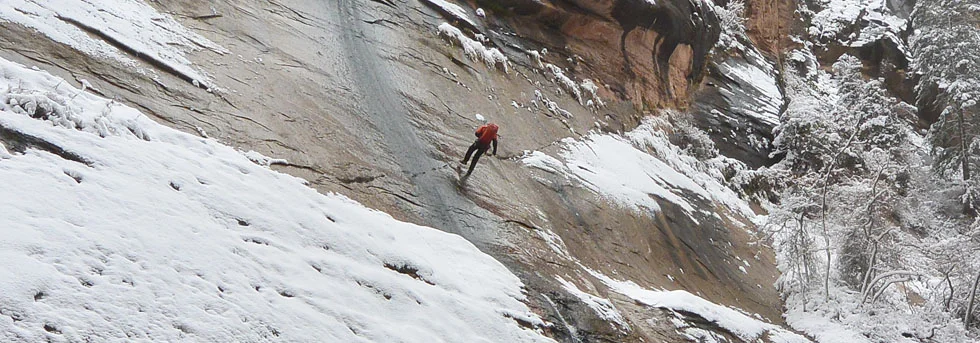
Winter : Hard to access with snowpacked approach trails.
GEAR and DIFFICULTIES
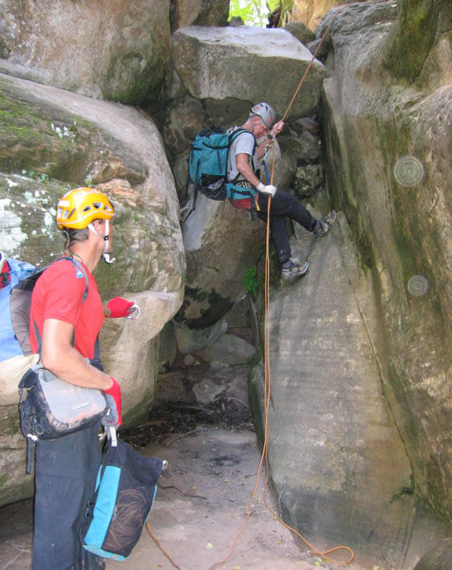
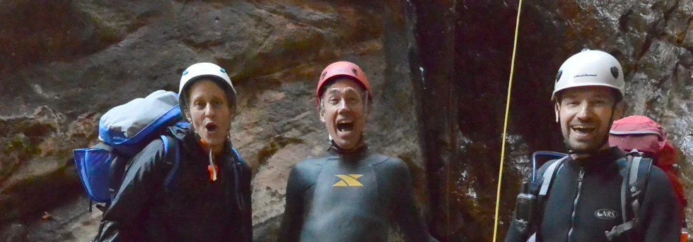
Mystery has about 10 rappels up to 120 feet (37m) in length. Bring webbing and rapid links to re-rig anchors as needed. Bring drybags or dry kegs for your gear – there are two mandatory swims near the end. The swims are short; wetsuits are not required if the weather is hot. Mystery has an exposed traverse that most parties will want to protect using a safety line or belay. Each member of the party will need a tether with locking carabiner to clip the safety line.
NAVIGATION
Finding the top of Mystery can be a challenge, so bring a map and use it. I’d like to think these directions alone are sufficient, but they are not. One or two parties a year start down the next drainage to the east (Miss-me) or to the west (Not-Mystery) and end up requiring a rescue. Make certain you are in the right place before heading down. If the approach does not look well-traveled, you are in the wrong place – go back!

Getting there
From Zion Canyon/Weeping Rock:
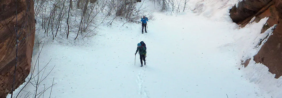
From Weeping Rock, ascend the Observation Point Trail up switchbacks below the face of Cable Mountain. It then cuts left into Echo Canyon, briefly following the streambed before climbing up the side on a cutout and getting back into the sun. More climbing across mixed slickrock and brush leads to the base of a buttress. Climb steeply up the buttress, switchbacking to the rim of the mesa. The trail follows the rim west toward Observation Point. One-third mile from Observation Point, the East Mesa Trail comes in on the right – this takes you to Mystery Canyon. Allow 2 hours to climb to the trail junction – 2.7 miles (4.3 km), ascent of 2100 feet (640m) – most of which is in the full sun after mid-morning.
The stroll out to Observation Point (1/3 mile, 1/2 km) provides a dramatic view of Zion Canyon, and is well worth a 30-minute diversion, if not pressed for time.
From the trail junction, follow the East Mesa Trail north then east through brush and ponderosa pines. After 20 minutes, and just after passing the trail's highpoint, a gorge can be seen through the brush to the left starting about 30 feet (10m) from the East Mesa Trail. Numerous small trails lead to the rim – follow them to the apex of Mystery Canyon.
From East Mesa/Ponderosa Ranch Approach:
The East Mesa Trail begins on the Park Boundary and is accessed through the Zion Ponderosa Ranch Resort. Allow an hour driving time from Springdale. Shuttles for hire are available.
From Springdale, take Route 9 through the tunnel to the East Entrance. Continue 2.4 miles east, then turn left (North) on the paved North Fork Road. Follow the winding road 5.1 miles to the Zion Ponderosa Ranch Resort; turn left into the Ranch. The dirt roads from here are rough and not well signed. Please be respectful of Ponderosa residents you encounter - afoot, on ATV, on horse or in cars. You are a guest on the Ranch. A few, but not all, of the turns are marked for "Observation Point".
0.0 miles: At the entrance, go straight (avoid going down to the main resort building to the left) past a residence. Pavement ends.
0.6 miles: Intersection - go straight for Observation Point (Twin Knolls Road).
1.4 miles: T - turn right on Beaver Road.
2.2 miles: Fir Road crosses - go straight on Beaver Road. Road gets rougher.
- Rough road, sometimes with deep ruts. Can be impassable when wet.
- Climbs over a hill. 2WD sedans might want to park at the top of the hill (1 spot). Down the other side of the hill.
2.9 miles: Y – go left for Observation Point.
- Fir Road comes in from the left.
- Messed up road, park at any time, several spots available.
2.95 miles: End of Road at Park Boundary: Parking lot.
The Trail:
Stroll west on the wide, smooth trail winding between huge Ponderosa pines with many signs of recent fires. Reach the top of Mystery Canyon at 2.1 miles (3.4 km). Mystery can be seen on the right for some time. Continue on the trail until it starts uphill to go around the left side of a small knoll. At this point, follow small trails through the brush right 30 feet (10m) to the edge of the canyon.
The Business
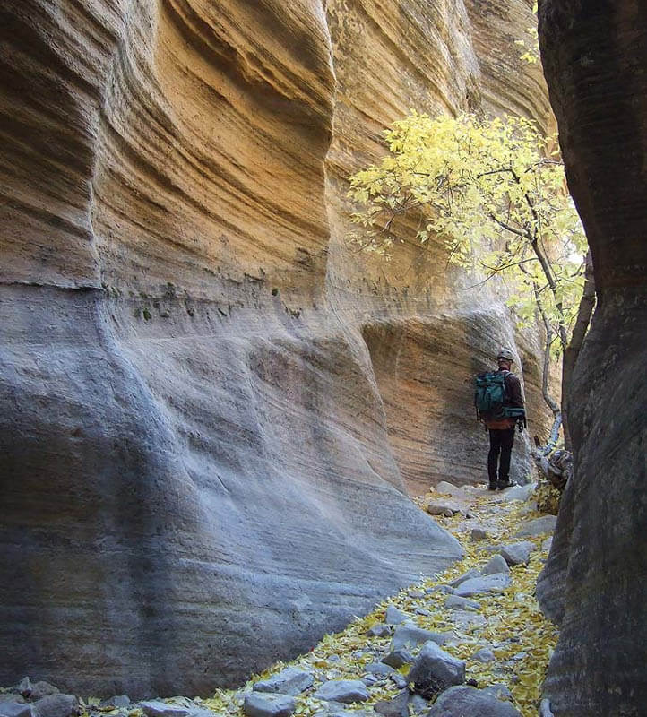
Make certain you are in the correct place – at the apex of Mystery Canyon. The canyon plunges spectacularly below you and extends straight north, with a series of mountains on the left all in a row. On the right, a steep, straight wall stretches north below a tree-topped mesa. A small but distinct trail leads down diagonally right across a steep shale slope.
Carefully follow trails steeply down through the woods for about half an hour. This section is known as "The Death Gully", though to date there have been no recorded fatalities.
Mystery is popular and is showing wear and tear from all our boots and sneakers. The Death Gully descends a natural erosion gully, and our passage does little to make it worse. In the next section of the canyon, several small drops are encountered. With no exceptions, descend these drops directly, rather than taking eroding paths to the side. By doing so, you minimize your impact.
After the Death Gully, the canyon flattens out, but has several short downclimbable drops. Bolt anchors are in place for those who prefer to rappel. The first is a short, clean drop. A few minutes further downcanyon, a short drop blocks the canyon. A shallow groove in the slab provides a surprisingly easy butt-slide descent. A rope can be used to sequence down all but the last member of the party, who can be spotted from below.
Several more short drops are downclimbed or rappelled. Further on, the canyon drops and is clogged with big logs. Downclimb the logs, then rappel from a bolt anchor at the end of the slot.
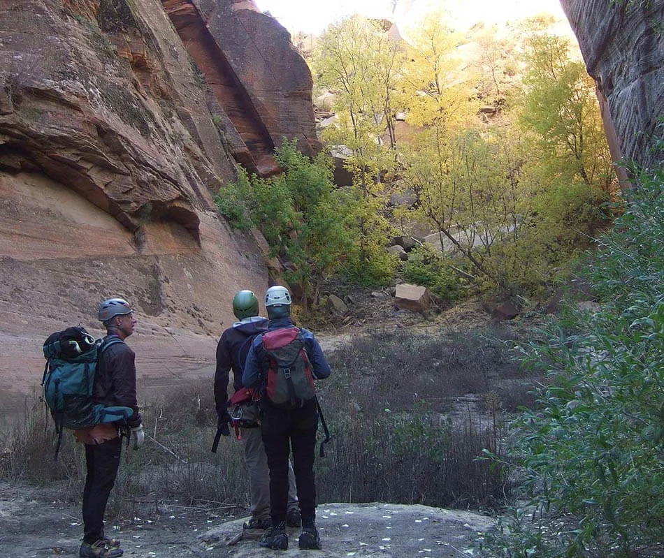
About 10 minutes further downcanyon, the slot jogs left and enters a section of cool, sculpted narrows with numerous rappels from fixed anchors. This is the Rock Narrows, and the count of "real rappels" begins here.
R1: 50 feet (15m) down a chute. Walk 40 feet.
R2:40 feet (12m) down a chute. Walk 40 feet.
R3: 30 feet (10m) down a chute. Slide down a short step. Walk about 50 feet (15m). A single, ancient bolt is positioned above a short, easy downclimb of 8 feet (2.5m). Twenty feet downcanyon, downclimb a log to a two-bolt anchor.
R4: 12 feet (4m) to the canyon floor. Walk 20 feet.
R5: 50 feet (15m) to a ledge then down a lower slab.
The canyon turns left and opens to the sun. Follow the slot 100 feet, including two short downclimbs, to an intimidating V slot. Downclimb through the slot. There used to be a rappel here as evidenced by bolts overhead. Walk 50 feet, then downclimb a V slot to a 2-bolt anchor at a chockstone.
R6: Rap 40 feet (14m) down a slab to a pothole ledge. Walk 10 feet.
R7: Rap 30 feet (10m) off a single bolt or downclimb to a round pothole.
This is a good place for lunch - the next section of the canyon is in the full sun. Apply sunscreen. The canyon opens up with the impressive south face of the Mountain of Mystery to the right. This section of canyon is often very hot. Follow the canyon past a few short scrambles to a flat area.
The flat area is a lake bed formed behind a giant landslide that crashed into the canyon in 1976 or 1977. When the upper canyon flashes, sediment is carried down to this point and deposited to build a flat plain. The same happened in Zion Canyon a couple thousand years ago, building a flat area from the Temple of Sinawava to below Zion Lodge.
Walk or swim across the flat area. Ascend the sandpile that blocks the canyon. A trail can be found that climbs up the right hand side. Drop down the far side of the sandpile. Carefully traverse a sandy ledge on the right side of the canyon and downclimb back into the bottom. Follow the canyon for a few minutes to the top of a steep slab blocking the canyon.
R8: Rap 50 feet (15m) from bolts down a slab.
Follow the watercourse as the canyon tightens up. A short drop is bypassed by hopping over a rock on the right and downclimbing a chimney. Another short drop is passed by climbing down a super-slippery log. By now, the canyon is delightfully shaded and cool. A few shallow pools are tiptoed around, then a groove is followed to some larger pools. Stemming around these pools leads to a slot and the slabs at the top of Mystery Springs. Carefully climb left a few feet and then down to the comfortable pothole ledge. This is a good place to gear up for the last section of the canyon and secure your gear in drybags or kegs.
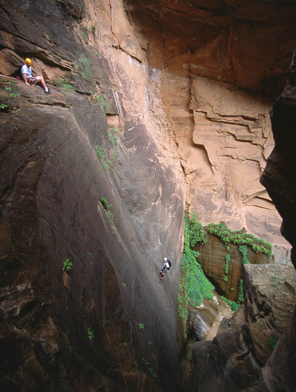
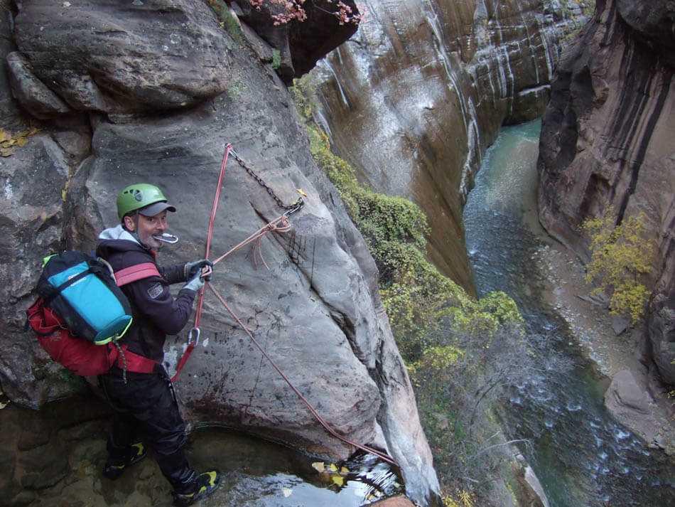
R9: 120 feet (37m) This is the exciting rappel into Mystery Spring. The anchor is at the far end of the slab. A single bolt at the near end can be used to set up a safety line or to belay folks out to the rappel anchor. Getting to the anchor is only 3rd class, but rather exposed.
Rappel into the pool at the base of the wall. This is a bit tricky, because the rappeller must rap to the top of a boulder in the slot below, which is to the side of the fall line; then continue the rappel off the boulder, down a slippery slot and into the pool. There is a chimney stance inches above the water where one can disconnect from the rope before swimming.
When pulling the rope, be sure it does not fall onto the boulder in the slot and get stuck. As it comes free, give it a gentle tug so the end falls towards you.
Downclimb a small cascade into a waist-deep pool. Further on, a boulder blocks the width of the canyon, creating a short drop with a turquoise pool below it. A small tree 10 feet back from the edge allows for a rappel. The chimney to the right can be downclimbed. This pool used to be a good jump, but floods in 2005 washed a lot of sand into the pool, and it is now too shallow to jump.
Continue downcanyon, downclimbing a short waterfall. After a short walk through the jungle, you arrive at the final rappel down Mystery Falls into The Narrows.
R10: Rappel 110 feet (34m) from bolts down the slippery cascade to the river. Many an expert canyoneer has embarrassed themselves on this rappel – try not to be among them. This is a good place to provide a bottom-belay for all rappellers.
The Mystery Downclimb Challenge
Mystery Canyon is a fun place to do some downclimbing. Bolt anchors are well-positioned to provide climbing belays above all but one downclimb. The last rap into the Narrows is off the table, but all the other drops have been downclimbed. Two drops are particularly difficult, meaning Tom has not done them and does not expect to ever do them.
To really make this work, it helps to have a dedicated, experienced belayer with an ATC-style belay device. Most of the downclimbs are high and tenuous, so I would not even THINK about doing them without a belay.
The downclimb following the watercourse into Mystery Spring (the upper pool) is among the best downclimbs I have ever done. A long sling can be set around the boulder at the top of the slot for making a belay. See how many you can do!

The Exit
Pack up the gear and hike downriver about a half-mile (800m) to a stone structure (The Veranda) at the end of the paved trail. Follow the Gateway to the Narrows Trail one mile (1.6 km) to the Temple of Sinawava shuttle stop.
Author's Experience
I first descended Mystery in July 1999 and have descended it about once a year since, usually in summer or fall. This is a challenging canyon in winter, which is why I tend to RAVE about it when we do it in winter.
Trip Reports
Maps
Click for higher resolution
Click for higher resolution.