
Hidden Falls Canyon, Red Rocks, Las Vegas

I've always been interested in those canyons cutting into the Red Rocks escarpment outside Red Rocks, and Lost Wages resident Dick Shear invited us down for the weekend. So it seemed like a good time to check out the first of these on his hit list - the main fork of Hidden Falls Canyon (aka Lost Creek Canyon), which descends into the Willow Springs Picnic Area.

But first, the mandatory Vegas stop to try to hit the jackpot! This time for sure!! Oh well... (Hidden Falls Canyon)

Just had a few pictures on this trip. After climbing to the crest of Buffalo Mountain, we drop over the other side into the canyon. Working our way down, we soon come to a short dryfall. Yes, it is possible to walk around and downclimb a ramp, but we chose to macrame a tree and do a short rappel.

Working our way downcanyon require not more than a little downclimbing (okay, a lot of downclimbing) till we interesect another branch coming in. Ah-ha! An impressive drop. We leave a sling on a tree and rappel 150′ to the canyon bottom. We had a little difficulty pulling it when the pull line and rappel line got twisted up, but soon freed it.
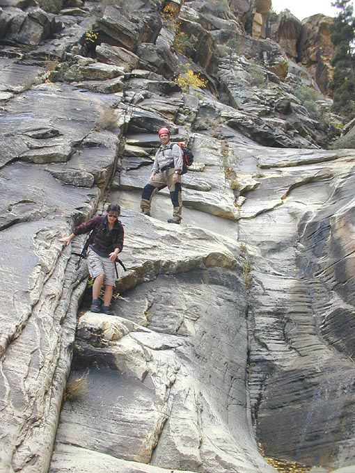
The rest of the canyon was pretty, and pretty mellow. There was a fair amount of 4th class downclimbing. Thankfully, the Red Rocks sandstone tends towards an abundance of holds, and at least in the watercourse, is generally sound. Here, Alicia and Dick downclimb a short section. We found a few more rappels lower in the canyon.
Trip Report: Hidden Falls Canyon, Red Rocks, Vegas, Nov 17, 2001
Overview:
a nice, technical canyon in the Red Rocks of Vegas. Requires a 2000 foot hill climb to get to the start, then about 8 rappels on the way down. It is a picturesque, moderate, natural anchors canyon with a fair amount of 4th class downclimbing.
Rating: 3A III ** Rappels to 150 feet. Restrictions: Red Rocks is a no new fixed anchors BLM Conservation Area. Bolts may only be added in an emergency. Water: none, bring plenty. Season: Fall or Spring. Most of the access route and most of the canyon is in the full sun. Logistics: Two vehicles (4WD preferred) can save you 2.25 miles of uphill walking.
Participants: Dick Shear, Alicia Scotter and Tom Jones. Notes from descent of November 17, 2001.
We arrived about 10am Saturday morning to the usual variety of sports enthusiasts enjoying the Red Rocks Conservation Area, and drove to the Willow Springs Picnic area. Checking the map, we drove onto the gravel road past Willow Springs, and followed it up a canyon that cuts in behind the Red Rocks Escarpment. At about 1.5 miles from Willow Springs, we found a small parking area and decided to take it. Since we only drove one car, one of us would have to jog back to the car to retrieve it, and I kinda figured it would be me. (Though we had a 4WD vehicle, a 2WD could easily make it up this road, Miatas excepted).
Dick had climbed most of the way up Hidden Falls Canyon (aka Lost Creek Canyon) last fall with Hank Moon and a few compatriots, climbing to the top via a side branch of HFC, and descending to the road where we now packed our gear. On that trip, Dick had smartly brought along a young buck climbing demi-god, and was able to make the ascent thanks to this feller providing a toprope on a few sections. The report was mellow and dry, so we took a 200' 8mm rope, a 150' 6mm pull cord, a bunch of slings and a bolt kit (to be used only in the most dire of circumstances). Given the late start and short days, we also all brought headlamps and warm clothes. Your basic 'loaded for Muskrat'.
Leaving the car, we hiked up the road another 3/4 of a mile, then cut over to the steep slope heading up Buffalo Mountain. If we had gone another 1/8 mile on the road, we might have found a decent trail. Instead, we headed up open scrub and snaked through short cliff bands, climbing at our aerobic capacity the 1500' slope to the top of the hill. Dick regaled us with stories from his very interesting life, which he insisted were NOT to provide him time to catch his breath. Nice views from the top.
From the crest of the hill, we dropped into the head of the canyon starting just on the other side. We hiked down perhaps an eighth of a mile before encountering the first drop - a 40' pourover. Though we could have skirted this drop by climbing around (quite a ways) on either side, we chose to rap it, found a tree to macrame and made swift work of it. Continuing downcanyon, we hopped down boulders and slid down slabs, occasionally pushing through some brush, to where a side branch of the canyon comes in on the right (close to the 1900m contour line). Here, our canyon drops 150' down a steep slab to join the other branch. After trundling a stump or two, we tossed a sling around a stout pine, and rapped to the canyon floor. As a lesson to Dick, I allowed the pull cord strand to get wrapped around the rapping strand, and had to clamber upcanyon a score of feet to find an advantageous pulling angle to get the ropes to pull. Get that, Dick? Don't do it that way.
We continued downcanyon, enjoying fine scenery. Downclimbing a few short 4th class sections, and after a quick lunch in the sun, we soon reached the intersection with the Left Fork that those guys had gone up before. If Dick could have remembered any of the canyon below this point, it would have been clear sailing. (Dick, you gotta lay off the bottle before noon)!
At this point, the canyon steepens and narrows. A fair amount of fourth class downclimbing was involved, and in a few places, a circuitous route was required. Plus a few rappels off natural anchors. One particularly interesting locale came to an apparent dropoff, only to reveal a hidden passage under and behind the large boulders. Look for the handy 'Metallica Rules' grafitti, which someone so kindly marked this passage with. A few fire rings indicate that this area can be accessed from below, though, as we were to discover, not without difficulty.
My how time flies. As we neared the mouth of the canyon, daylight was waning. At one point, Alicia and Dick rapped off my belay around a tree, then I downclimbed a heinous 5.4 8' boulder problem on canyon left. As the shadows deepened, we arrived at a 50' drop with no obvious line of descent. No tree or chockstone presented an obvious natural anchor, so we traversed canyon left about 40' (5.2) to a single, new fixed pin, and generously allowed Dick to go first. Aft the pin proved its mettle, Alicia and I soon joined Dick on the canyon floor, carefully avoiding a shallow pool. (This line of rappel was where those guys ascended (5.4?), but at that hour and in fading light, rapping off the fixed pin was more expediant).
At the next drop, we used the last of the fading light to traverse left and work our way down, following signs of traffic. Except for a brief encounter with a cactus, the path found was moderate. Rather than continue down Hidden Falls Canyon, we slabbed left across to the top of the cliffs overlooking the Willow Springs picnic area. By cutting far left, we found our way to the main canyon floor without further ropework.
Time: 10 am to 7 pm, with 1 hour for lunch and a fairly casual pace.
A good time was had by all.
Large Map (474K) (Hidden Falls Canyon)