Crack Baby in Kanab Creek, Grand Canyon, and the usual torture

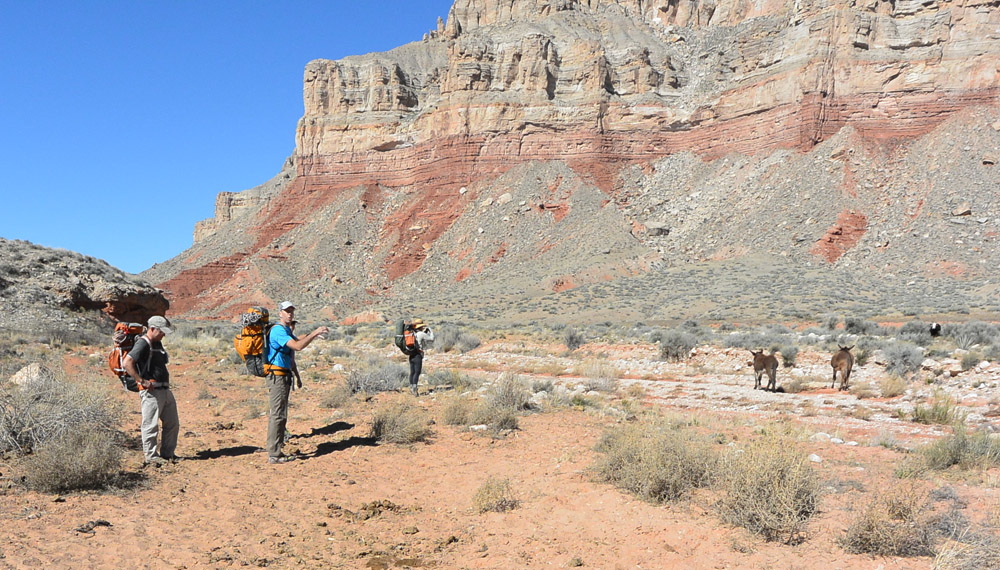
Crack Baby is one of the closest Grand Canyon Redwall Limestone slots to "the road", and was thus chosen for a quick trip for a photo shoot. "Give Tom Jones a call", said Rich Rudow, (almost) heading out the door for a 30-day Grand Canyon trip. So Kristen Caldon, photographer on a Sierra Club project, called me, and we threw together a quick trip. Bruce Wilson from St George, and Chris Grove and Christine Ame from Flagstaff signed up. We rendezvoused at the Tuweep Road parking lot and drove down Hack Canyon to the Wilderness boundary. There is a direct route to Crack Baby, from Flipoff Point, which Bruce had done last year. And he said what most people apparently say after doing that approach: "Never AGAIN!". Usually with some French thrown in, though Bruce is a gentleman and such words do not become him. Rich knew my inclinations, that I am not a *Grand Canyon Hike*, and suggested the longer but much flatter Hack Canyon route, which gave the illusion of being a reasonable route by sitting-on-my-butt-for-a-month standards. I mapped it out, and we had a plan.
As it turned out, the plan was for Tom to finally thoroughly comprehend Todd Martin's remark: "Frakkin' Supai"!
This trip was a chance for me to get the new woman's Heaps pack (Shinumo), production version, out in the field for some testing and pictures. Bruce and I got new version Heaps packs, Chris used his somewhat broken in Heaps from last year. Reviews all around were "thumbs up!"

Good trip for Tom!
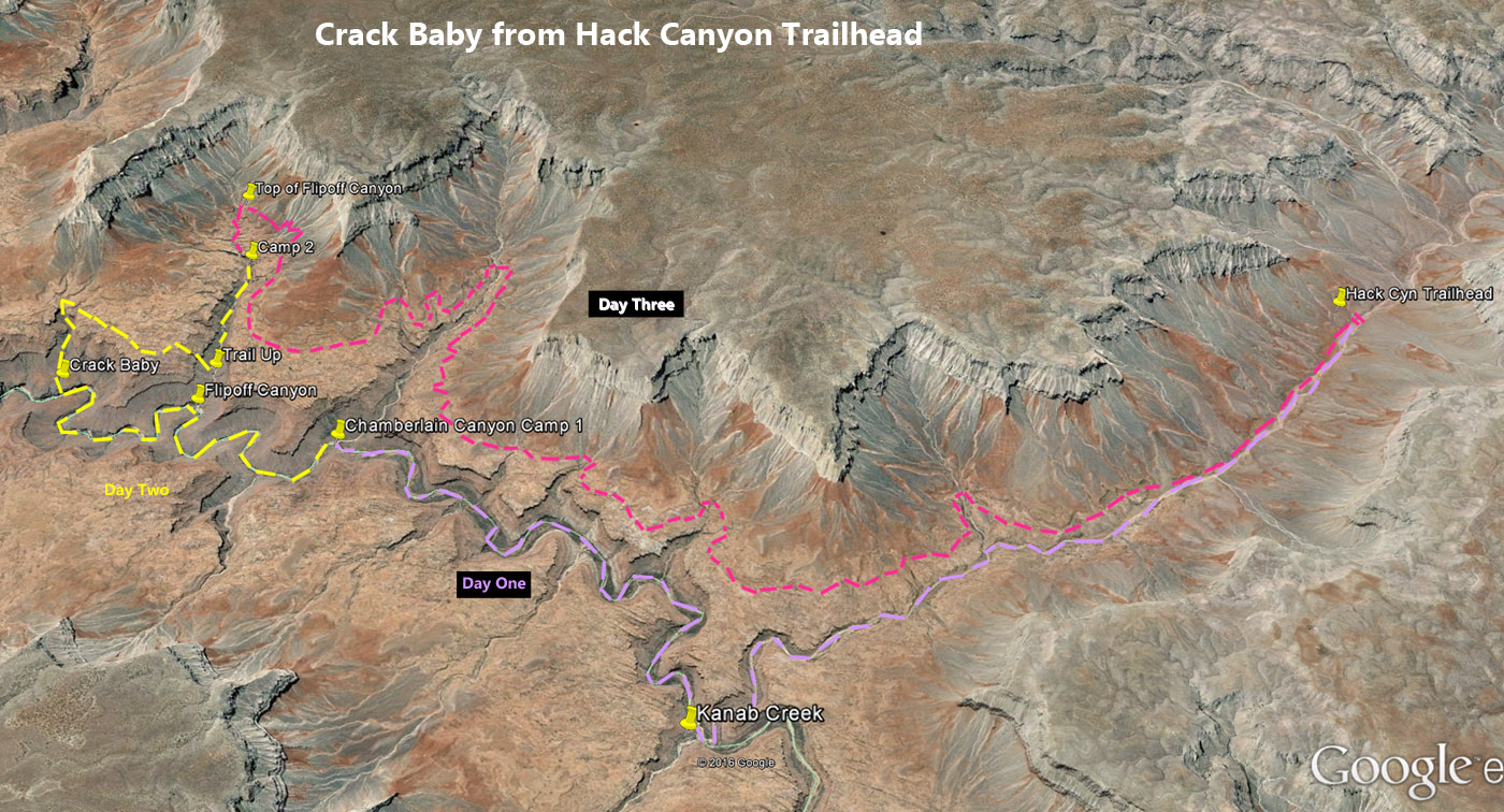
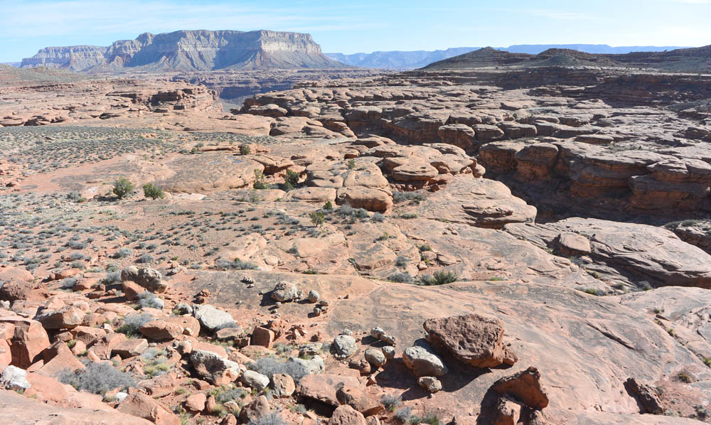
THE PLAN: there are two routes that connect the Crack Baby area and the Hack Canyon trailhead. One can simply walk down Hack Canyon to Kanab Canyon, then down Kanab to Crack Baby. This sounds simple and straightforward; those who know my will then ask how did I make this more complicated? One can also hike up on the Supai (Esplanade level) to get to the top of Flipoff Canyon, and take Flippoff down through the Supai to the top of the Redwall, thus to Crack Baby. We figured to take that route on the way in, so we could get both canyon pictures and Esplanade pics, and for the variety of scenery. Which would be a good plan except for the frakkin' Supai. Rich mentioned horse packer trails in the area, including across the Supai, so it would be cake.
The Actual, not The Plan
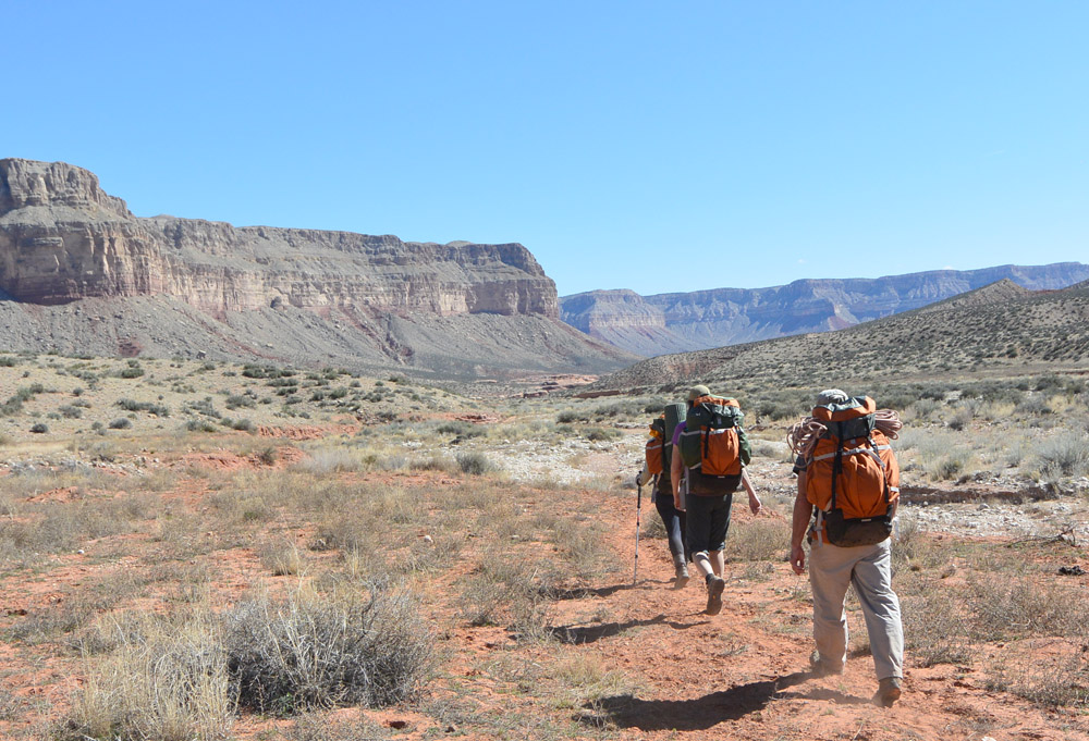
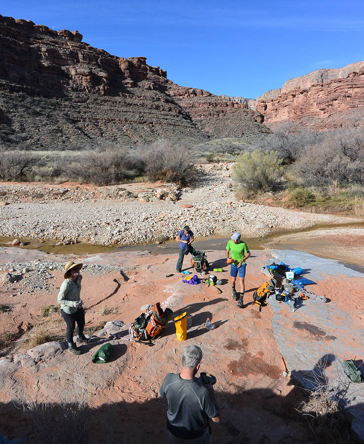
There is no cake in the Grand Canyon. As Helmuth von Moltke the Elder said, "No plan survives contact with the enemy". We rambled down Hack Canyon 5.3 miles, keeping an eye out for the exit up to the Esplanade. It escaped our notice, and we found ourselves, without too much difficulty, at Kanab Creek. We sauntered down to Chamberlain Canyon, a further 3.9 miles, found decent water, and made camp on a slickrock bench just off the creekbed. It was delightful.
Camp at Chamberlain
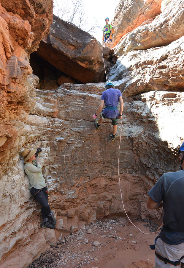
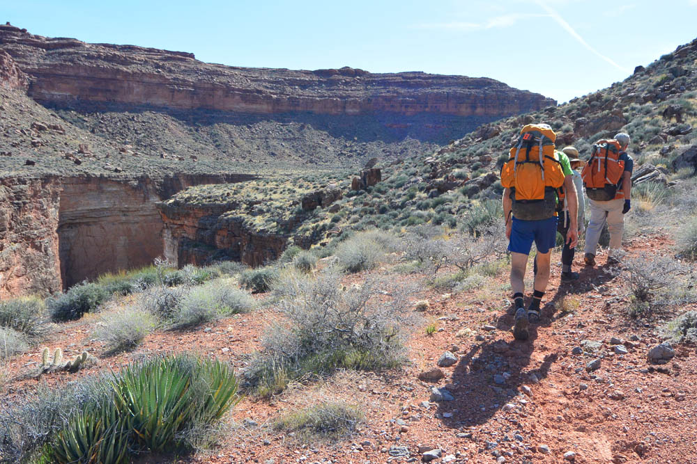
Day Two - we packed up and strolled the 1.9 miles to Flipoff canyon. A short hike up Flipoff, and we found a place to cache our overnight gear, consolidated into fewer packs, and hiked the top of the Redwall 1.5 miles around to Crack Baby. The setup here is ideal: Flipoff Canyon hits Kanab just a few feet below the Supai/Redwall contact. Hike 100 feet up Flipoff, climb an easy little cliff, and you are atop the Redwall on a pretty good horse-packer trail. We followed the trail 1.5 miles downcanyon and voila, Crack Baby. We drop into the canyon, walk down a few steps and come to the first drop, indicated by a sling around a tree. We discuss pulling the sling and Fiddling, but Grand Canyoneers might not have much in the way of extra webbing. This short little drop was perhaps downclimbable, but we rapped.
Hiking the Redwall around to Crack Baby
Second rap appears, and possibilities for exciting photos are possible. The rappel itself is not too exciting, but a rock to the side would allow a "Bird's eye view". Bruce raps first, to provide a bottom belay for both the rappeller and for Kristen. Kristen goes down the side on a rope and locks off in position, the big Nikon seeking targets... Chris and Christine rappel slowly (separately); photos are taken. All down but me. I unwrap Kristen's rappel rope, and bring it over to the main point to use as the clean on the Fiddlestick. I move the Fiddle to a better location, re-set. The rap start is awkward, so I sling the pack and lower it over the edge, make sure the ropes are straight, downclimb over the edge and rap to the ground below. We pull and coil, walk the 20 feet to the next rap.
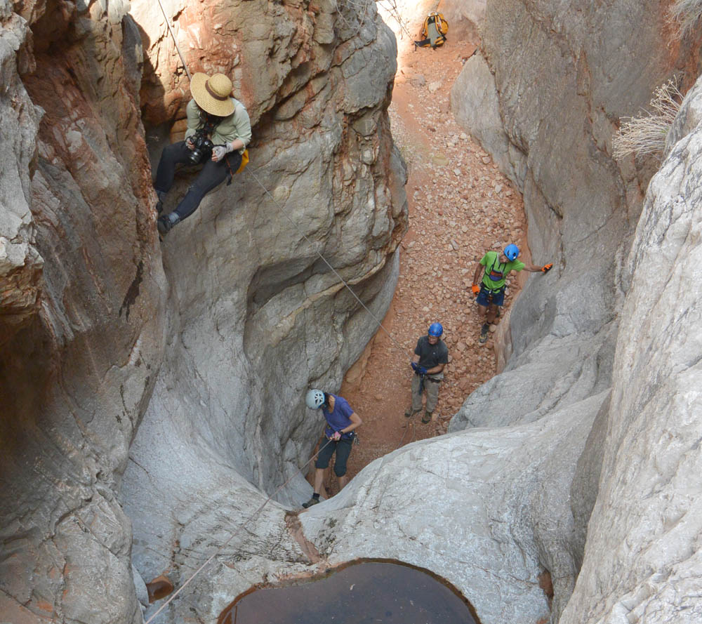
Photoshoot in Crack Canyon
It is only when I get set to rap second to last that I notice my camera is not with me. I look around but no. With all the happenings at the last rap, I failed to put the camera case around my neck.
We put on wetsuits, then do the third rap. And finally the final, dramatic rap off an odd anchor. Rich had warned about this one, often underwater, hard to see, and when they pioneered the route, one person had to hold it in position, under the water, while other people rapped. For us, the pool was 5 feet lower and it was secure, but still one of the MOST awkward rappel starts EVER! Down and into a swimmer, short but cold. A quick downclimb and we were back in Kanab Creek, looking for sunshine.

Swimming the cold pool
We had a casual pace through the day; now I was in a hurry. Chris (the fittest of the crew) offered to go fetch the camera, but I (the least fit) considered, as frak-upper, to be MY duty to go the extra 3 miles to fetch my camera. Pride over smarts. We pulled out the map and made a plan - I would go fetch the camera, they would have lunch, then follow. Pick up the gear and hike UP Flipoff and over to the top of Chamberlain to camp - I would chase and find them by headlamp. I gobbled down some lunch, left my wetsuit for those guys to carry back to the packs, and started trotting upcanyon. I made good time to Flipoff, grabbed a fresh quart of water from Kristen's pack, and climbed up the short bit to the horse trail. Trotting again, I made decent time across the top of the Redwall back to the canyon.
So how long could it take to get up the canyon? I had about an hour before dark. After an hour I was about halfway up the canyon. The Supai breaks into big boulders that fall into the canyon. At times, these are troublesome to get past. In my tired state, with an almost large pack on, they were more than troublesome, but thankfully short. The other thankful thing was, as it got dark, I heard voices ahead. My team had contact with reality, and made an executive decision, found water in the canyon, took off their packs and settled in. Smart. Especially for me.

Second Camp
Day Three - we got up early. Quick breakfast, on the trail in the cool of the morning. Up through more Supai junk. At the top of the canyon, the canyon bends away from our objective, but we follow the canyon until we can break out. Atop the Supai, we work around the head of the canyon as it cuts into the steep stuff above. Up steep slopes, down steep slopes. A bit of a trail for a while. Then another steep gully. An hour of hard work gets us around the head of Flipoff and over to the next canyon north, the south fork of Chamberlain, where we were scheduled to spend the previous night, kinda sorta. Rich said there is water down there somewhere. Good thing we did not try to find that in the dark, because getting INTO the head of the canyon involves a 60 foot cliff, which might have a break SOMEwhere. And then there might be water SOMEwhere. The day has started to warm up, and the sun is hot and unrelenting. At least we are walking mostly with it behind us.

Tom hiking up around Chamberlain
Chamberlain turns out to be a very big deal at this level. Going down a level is not in the cards. We work our way around the South Fork, then head over to the main fork, which cuts (again) into the steep hillside. How many gullies? Hrair. By now we had found the slightly faded horse-packer trail, and could follow it in many sections. Although the pattern was, when you needed it most, it would mysteriously disappear. A clear trail would lead to the edge of a gully, and then... nothing. A few hoof prints here and there, a few old human prints, and for me, walking well to the rear, a few scattered shoe prints where my companions guessed... so off-trail into the gullies, across steep terrain, trying to sniff out a reasonable path. Once in a while, at the bottom of a gully, the well-established horse-trail would appear to allow easy escape up the other side, and it would allow itself to be followed for a few minutes before becoming coy, again.
I think it took two hours to get around Chamberlain. The rest of the group, moving faster, would soon be ahead of me, and take a break where shade was to be found. When I caught up, we exchanged words such as these:
"Whew, glad we are finally around that canyon and back on the path."
"Yes, good thing. Looking at the map, looks like smooth sailing from here. That was the last big canyon. Five miles as the crow flies, perhaps seven by our route."
Then we would walk about 100 feet, turn a corner, and a giant canyon cuts into the Supai, extending back into the steep crap above. An hour later, I would catch them rested in the shade.
"Whew, glad we are finally..."
Etc. Repeat.
The beautiful Supai
But, even Hell is not eternal, at least for us atheists. Eventually, the Supai relents, we cross some final hills, the sun slips behind the escarpment above, and the trail dumps us into Hack Canyon. A few more miles, now really truly smooth sailing though perhaps a bit soft, and just at dusk, Bruce (who has generously waited to walk with me the final miles) and I find ourselves in the rank, thoroughly cowed up section that indicates our journey is soon over. And then Chris's Four Runner, and the legs can finally stop moving.
Then I ate for four days.