• Home
  • About Us
    • About Canyoneering USA
    • About Tom
    • The CUSA Story
      • Zion Canyon Coalition
      • First CUSA Site
      • Canyon Fests
      • Imlay Canyon Gear
    • The CUSA Team
      • Jenny West
      • Tom Jones
      • Felicia Bicknell
      • Sarah Stratton
      • Nick Wilkes
      • Steve Ramras
    • Client Endorsements
  • Utah Canyoneering Guide
    • Introduction
      • Staying Alive
      • Social Etiquette
      • Using This Guide
      • Canyon Ratings
      • Technical Skills
      • Flash Flood & Hazards
        • Tracking a Zion Flood
        • White Canyon Flash Flood
        • Quandary Canyon Cautionary Tales
      • Training & Guiding
      • Maps
        • Map Download Center
      • Ethics & Style
      • Minimum Impact
    • Cedar Mesa
      • Black Hole of White Canyon
      • Gravel Canyon
      • Cheesebox Canyon
      • Fry Canyon (w/ the Frylette)
    • Escalante
      • Escalante Archives
      • Visitor Info
      • Upper Calf Creek Hike
      • Lower Calf Creek Hike
      • Choprock Canyon
      • Coyote Gulch Dayhike
      • Davis Gulch
      • Egypt 3
      • Upper Harris Wash
      • Neon, Fence & Ringtail
      • Peek-a-Boo, Spooky & Brimstone
      • Phipps Canyon
    • North Wash
      • Leprechaun Hike
      • The Hog Canyons
        • Hog Three
        • Miss Piggy
      • Leprechaun Forks
      • Sandthrax
      • Foolin' Around
      • Shenanigans
      • Woody Canyon
    • Robbers Roost
      • Chambers Canyon
      • Big Bad Ben
      • Bluejohn Canyon
      • Larry Canyon
      • Ho Hum Fork
      • Mind Bender Fork
    • San Rafael Swell
      • Central Swell
        • Crawford Draw
        • Eardley Day Hike
        • Eardley Canyon
        • Forgotten Canyon
        • Reid Nelson to Crawford Draw
        • Upper Straight Wash
      • Eastern Reef
        • Crack Canyon
        • Chute Canyon
        • Crack/Chute Loop
        • Ding & Dang Canyons
        • Eardley Technical Hike
        • Farnsworth Canyon
        • Little Wild Horse & Bell Canyons
        • Lower Straight Wash
        • Wild Horse Canyon
      • Moroni Slopes
        • Lower Squeeze Canyon
        • Segers Window Canyon
      • Northern Reef
        • Box & Double Arch Stroll
        • Box & Double Arch Walk
      • South Central Swell
        • Baptist Draw to Upper Chute
        • Upper Chute Canyon
      • Southern Reef
        • Grand Gorge of Muddy Creek
        • Knotted Rope Direct
        • Knotted Rope Hidden Splendor
        • Knotted Rope Ridge Walk
        • Mud Canyon
        • Music Canyon
        • Quandary Canyon
      • Tomsich Butte
        • Penitentiary Canyon
    • Zion National Park
      • Visitor Information
        • Getting Around
        • Geologic History
        • Human History
        • Permits & Wilderness Desk
        • Springdale
      • Zion Hikes
        • West Rim, Bottom-Up
        • Angels Landing
        • Cable Mountain
        • Canyon Overlook
        • Chinle Trail
        • Coalpits Wash
        • Deertrap Mountain
        • Eagle Crags
        • East Mesa
        • East Rim
        • Emerald Pools
        • Grafton
        • Hidden Canyon
        • Hop Valley
        • Kolob Arch
        • M. Fork Taylor Creek
        • Northgate Peaks
        • Observation Point
        • Pa' Rus Trail
        • Riverside Walk
        • Sand Bench
        • Watchman
        • Water Canyon
        • Weeping Rock
        • West Rim
      • Off-Trail Hikes
        • The Barracks
        • Clear Creek
        • Kanarra Creek
        • Lady Mountain
        • Lower Pine Creek
        • Many Pools
        • MIA Access Route
        • Right Fork, Bottom-Up
        • Shelf Canyon
        • Squirrel Canyon
        • Spring Creek
        • Subway, Bottom-Up
        • S. Fork Taylor Creek
        • The Zion Narrows
          • Bottom-Up
          • 1-Day Thru-Hike
          • Overnight Thru
      • Technical Canyons
        • Rock Canyon
        • Behunin Canyon
        • Birch Hollow
        • Boundary Canyon
        • Corral Hollow
        • Das Boot
        • Echo Canyon
        • Englestead Hollow
        • Fat Man's Misery
        • Grotto Canyon
        • Heaps/Imlay Intro
          • Heaps Canyon
          • Imlay Canyon, Sneak
          • Imlay Canyon, Full
        • Hidden Canyon
        • End of Hidden Canyon
        • Hook Canyon
        • Icebox Canyon
        • Isaac Canyon
        • Keyhole Canyon
        • Kolob Canyon
        • Lodge Canyon
        • Mystery Canyon
        • Observation Point
        • Orderville Canyon
        • Pipe Spring Canyon
        • Pine Creek Canyon
        • Lower Refrigerator
        • R. Fork of North Creek
        • Russell Gulch
        • South Fork Oak Creek
        • Spry Canyon
        • Spearhead Canyon
        • Subway from the Top
        • Telephone Canyon
  • Tech Tips
    • Tech Tips
    • Gear Guide
  • Latest Rave
    • Latest Rave
    • Archive 2001 - 2010
    • Archive by Location
  • CUSA Store
    • CUSA Store Home
    • Canyoneering Top Nineteen
    • Anchoring
    • Camping & Backpacking
    • Canyon Maps & Guidebooks
    • Canyon Packs
    • Canyoneering Rope & Tools
    • Canyoning Things Worn
    • Emergency & Repairs
    • Gift Card/Certificate
    • Lighting
    • Logo Wear
    • Technical Hardware
    • Water: Kegs, Drybags, Boats
    • Water Treatment
  • Books
    • Zion: Canyoneering
    • CUSA Books
    • Zion Wildflowers
    • Canyoneering 101
    • Knots & Rigging for Canyoneering
  • Links
  • Feedback

Sandthrax, North Wash

Life in the Fast Lane

View of Sandthrax and Henry MountainsView of Sandthrax Slot and the Henry Mountains

"She had a nasty reputation as a cruel dude,
They said she was ruthless, said she was crude..."

She had a nasty reputation as "impossible", which has diminished of late due to several descents, but among veterans she inspires a hefty respect.

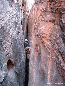
Sandthrax is a short, intense canyon in North Wash, next to the Leprechaun system. The stopper section is a 5" to 10" vertical crack about 15 feet tall, with 30 feet of exposure. It has been stemmed up high - very exposed and rated as 5.11c(?) - no thanks! The few who have tried to really free it say very awkward hard 5.10 or ... Personally, AFTER aiding as high as I could on two #6 Camalots, I thought it was still hard 5.9 or 5.10 to get over the top. Needless to say, intelligent Sandthraxers need a robust strategy for passing this obstacle.

Outside this short bit, the canyon is a quite nice, sustained, not extremely difficult X- (X minus) high-stemming/mae west canyon that can be quite pretty and is fun for the mae-west-proficient. Most of the canyon can be cautiously passed in a back-feet chimney, with only a couple silos that require stretching out more, although the length of the sections without relief can be quite daunting. Don't underestimate the rest of the canyon - it is grueling.

  • Profile
  • Approach
  • The Business
  • Exit
  • Maps & Info
  • Trip Reports
  • Gallery

LOGISTICS

Ram stemming in SandthraxRam stemming in the slot

  Rating 4A III (SLOT X), 5.10 C2 yellow_staryellow_staryellow_star
  Season Late Fall, Winter or Early Spring
  Time Commitment
3 to 6 hours
  Longest Rappel
35 feet (11 m)
  Access
Easily done walking from Sandthrax/Leprechaun campsite
 

EQUIPMENT

  Essentials

Full padding and body protection.

70 feet dynamic rope: there are two short rappels in the canyon, up to 35 feet in length; and a belay possible across one of the silos. Bringing a dynamic rope will allow a dynamic belay on the crux.

Climbing Rack:
1-#5 Camalot
2-#6 Camalot
1-larger piece such as a #4 Big Bro or a 12" woodie


This allows the #5 Camalot at the base of the crack to position the rope, two #6 Camalots to climb most of the crack and one other piece to place above, either for aid or protection and also to anchor a rope for the seconding member of the party to ascend. Most parties will find a set of etrier handy, and rope ascending gear. (The crux has also been passed with a pack toss and some rather skilled climbing).

Rim Team: Many parties go in with a rim team utilizing a 300' rope and at least two people. The crux can be supported from the east rim without too much difficulty.


DIFFICULTIES


  Flood Risk
High--sustained narrow sections
  Skills Required

Difficult up-climbing and moderately difficult sideways climbing is required.


The Approach

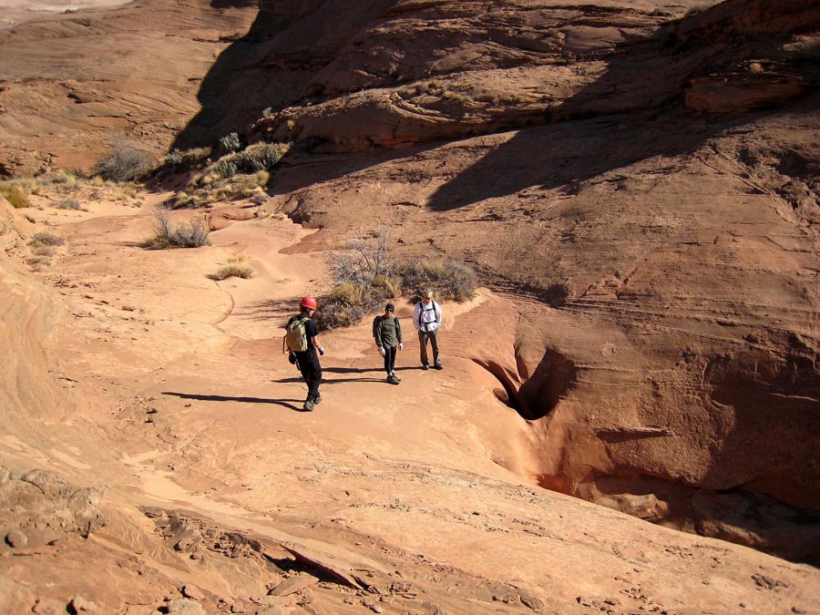
Gather the team and hike to the mouth of the canyon, where it exits the sandstone as a 3" slot. Back down canyon then up on the righthand (LDC) side, then follow the west side of the canyon to the head. Allow about 20 minutes.

Sandthrax Approach PhotoView of the Sandthrax Slot from the Top

The Canyon

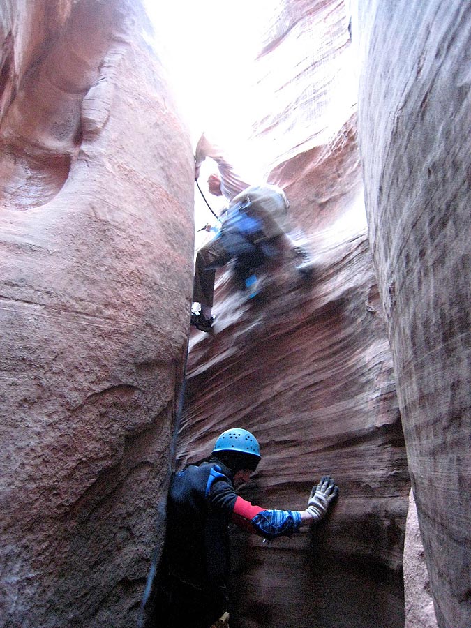
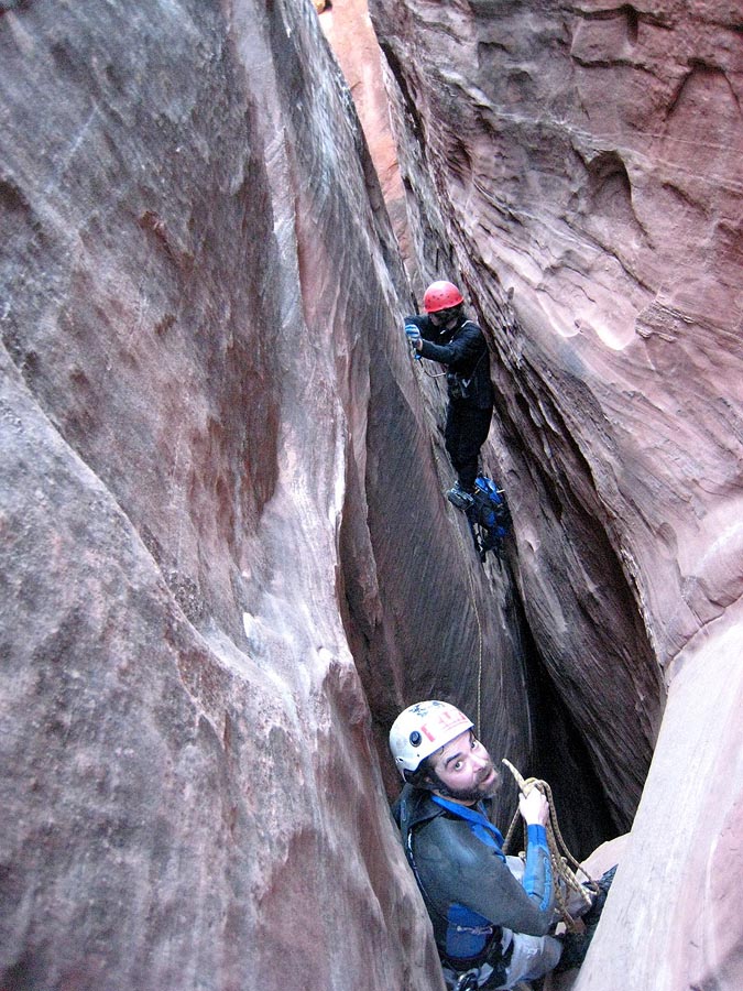
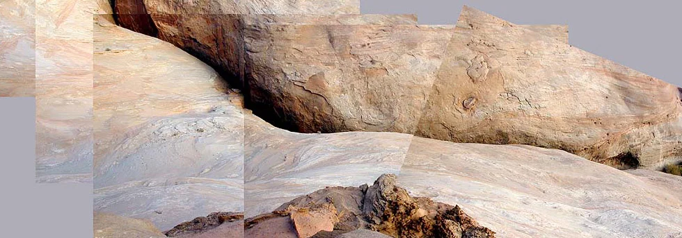
Gear up and start into the canyon with a bit of a downclimb. A short rappel is soon found - a sling around a rock provides anchorage. Say "Now we're in for it" to your partner. A bit of downclimbing and clambering across some nice small potholes to the first nasty bit - an exposed stem and climb up a nose to attain the high-ground above an extremely narrow slot. A belay and aggressive spot may be helpful in passing the exposed nose.

What follows is quite a long section of mae west passage above a deep and narrow slot. Pace yourself carefully and enjoy the absurdity of your situation. Forty-five minutes into the canyon, at a choice of up or down, take the elevator down to some nice ledges. Soon after, you are forced pretty low, where you can see the bottom of the canyon, followed by a strenuous squeeze chimney up to some wedged chockstones. This is a good place to rest.

A yawning silo is reached, which can be belayed off a drilled pin for both first and followers. The exposure is daunting, but the moves are not too difficult. A few feet beyond the silo, a steep elevator is taken down to the crux. Pass the crux (yields easily to good technique).

More interesting climbing is found after the crux. A wonderful 100-yard, very straight section dips down, then climbs up and right over to a second rappel off huecos. Then comes a very dark section on the ground, that opens to a strolling mini-subway section. The right rim is tantalizingly close. Don't let your guard down, there is more business ahead. The bottom drops out at an easy bombay stem. One more silo is passed in an area of poor quality rock and then, all too soon, the satisfied Sandthraxer finds him- or herself looking out at the mouth of the canyon. A short downclimb pops one out on the canyon floor.


The Exit

You should pop out right back at the Sandthrax/Leprechaun Complex campsite.

AdobePDFicon

Download PDF
Printable PDF

PDF Canyon Guide

A printable canyon description you can take with you.

sandmapMap of Sandthrax Canyon, North Wash

Detailed Route Maps

Click on any map to browse a larger view,
then right-click to save and print.


Author's Experience

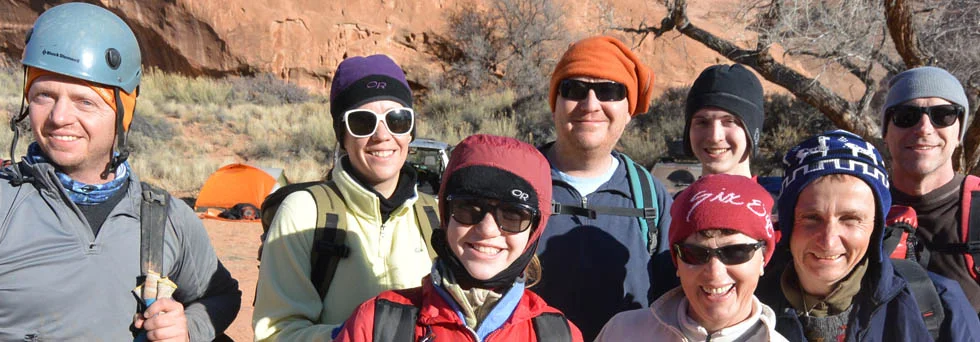
Sandthrax IS a big deal, at least to those of us who are not X-canyon regulars. I have done it exactly once, with Ram and Wade Christensen in November 2007. I hope to get in shape to do it again.

Trip Reports

The Chasm of Doom, November 2001
Freezefest Descent, December 2006
Matt Brejcha, FreezeFest

Video

Sandthrax Canyon, 10/11/2012, by Rob Bay  

Stories

Sandthrax, by Hank Moon--Canyon Tales
Mae West Slot, by Dave Black--Canyon Tales


External Links

Alternative Descriptions

Shane Burrows, Climb-Utah.com


Sandthrax UpclimbA Difficult Upclimb at the End of Sandthrax

N. Wash Menu

  • Introduction
  • Cedar Mesa
  • Escalante
  • North Wash
    • Leprechaun Hike
    • The Hog Canyons
    • Leprechaun Forks
    • Sandthrax
    • Foolin' Around
    • Shenanigans
    • Woody Canyon
  • Robbers Roost
  • San Rafael Swell
  • Zion National Park
© 2013 Canyoneering USA. All rights reserved. Site design by Isthmus Design.
Canyoneering USA | P.O. Box 5532 | 2625 South State Street | Mt. Carmel, UT 84755 | USA | 435.648.3089 | CanyoneeringUSA at gmail dot com